San Jerónimo Coatlán geodata
San Jerónimo Coatlán (Oaxaca) is a seat of a second-order administrative division; located in Mexico in America/Mexico_City (GMT-6) time zone. With population of 961 people, there are 9056 cities with bigger population in this country. Compared to other cities in Mexico, 96.1% of cities are located further ↑North; 76.4% of cities are located further ←West and 59.8% of cities have lower elevation than San Jerónimo Coatlán. Note1


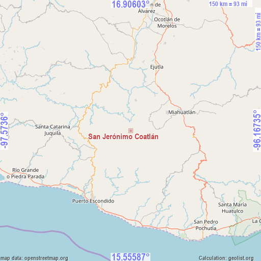
San Jerónimo Coatlán GPS coordinates[2]
16° 13' 55.596" North, 96° 52' 13.692" West
| Map corner | latitude | longitude |
|---|---|---|
| Upper-left | 16.90603°, | -97.5736° |
| Center: | 16.23211°, | -96.87047° |
| Lower-right: | 15.55587°, | -96.16735° |
| Map W x H: | 150.1×150.1 km | = 93.3×93.3mi |
| max Lat: | 32.7° ⇑96.1% North |
| San Jerónimo Coatlán: | 16.23211° |
| min Lat: | ⇓3.9% South 14.53588° |
| min Long | San Jerónimo C | max Long |
| -117.105° | -96.87047° | -86.73105° |
| W 76.4%⇐ | ⇒23.6% E |
Elevation
Elevation of San Jerónimo Coatlán is 1722 m = 5650 ft, and this is 468.3 m = 1536 ft above average elevation for this country.
| Max E: |
3497 m = 11473 ft | 40.2% |
| San Jerónimo Coatlán | 1722 m 5650 ft | |
| Avg. | 1253.7 m = 4113 ft | |
Min E: |
-1 m = -3 ft | 59.8% |
See also: Mexico elevation on elevation.city.
Geographical zone
San Jerónimo Coatlán is located in North Torrid zone (between Equator and Tropic of Cancer). Distance of this Northern Tropic circle is 801.1 km =497.8 mi to North.| Distance of | km | miles | from San Jerónimo Coatlán |
|---|---|---|---|
| North Pole | 8202.2 | 5096.6 | to North |
| Arctic Circle | 5596.3 | 3477.4 | to North |
| Tropic Cancer | 801.1 | 497.8 | to North |
| Equator | 1804.8 | 1121.5 | to South |


Nearby cities:
15 places around San Jerónimo Coatlán: (largest is in red/bold)
• Las Palmas
21.7 km =13.5 mi,  241°
241°
• San Baltazar Loxicha
19.4 km =12.1 mi,  152°
152°
• San Cristóbal Honduras
21 km =13 mi,  299°
299°
• San Francisco Coatlán
13 km =8.1 mi,  115°
115°
• San José Llano Cieneguilla
22.9 km =14.2 mi,  189°
189°
• San Miguel Coatlán
19.2 km =11.9 mi,  101°
101°
• San Pablo Coatlán
9.3 km =5.8 mi, 95°
• San Pedro Coatlán
13.7 km =8.5 mi,  79°
79°
• San Sebastián Coatlán
5.8 km =3.6 mi,  125°
125°
• San Vicente Coatlán
17.6 km =10.9 mi,  9°
9°
• Santa Ana
20.4 km =12.7 mi,  53°
53°
• Santa Catarina Coatlán
12.7 km =7.9 mi, 54°
• Santa Catarina Loxicha
22 km =13.7 mi, 145°
• Santa Cruz Xitla
23.3 km =14.5 mi,  64°
64°
• Soledad Piedra Larga
19.9 km =12.4 mi, 237°
Sources, notices
• [Note1] Compared only with cities in Mexico existing in our database
• [Src1] Map data: © OpenStreetMap contributors (CC-BY-SA)
• [Src2] Other city data from geonames.org with taken over terms of usage.
• [Src3] Geographical zone / Annual Mean Temperature by Robert A. Rohde @ Wikipedia
