San José Llano Cieneguilla geodata
San José Llano Cieneguilla (Oaxaca) is a populated place; located in Mexico in America/Mexico_City (GMT-6) time zone. With population of 972 people, there are 8937 cities with bigger population in this country. Compared to other cities in Mexico, 97.2% of cities are located further ↑North; 76% of cities are located further ←West and 61.1% of cities have higher elevation than San José Llano Cieneguilla. Note1
Current local time in San José Llano Cieneguilla:
11:33 AM, MondayDifference from your time zone: hours


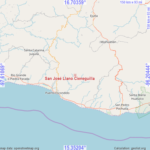
San José Llano Cieneguilla GPS coordinates[2]
16° 1' 44.256" North, 96° 54' 27.216" West
| Map corner | latitude | longitude |
|---|---|---|
| Upper-left | 16.70359°, | -97.61069° |
| Center: | 16.02896°, | -96.90756° |
| Lower-right: | 15.35204°, | -96.20444° |
| Map W x H: | 150.3×150.3 km | = 93.4×93.4mi |
| max Lat: | 32.7° ⇑97.2% North |
| San José Llano Cieneguilla: | 16.02896° |
| min Lat: | ⇓2.8% South 14.53588° |
| min Long | San José Llano | max Long |
| -117.105° | -96.90756° | -86.73105° |
| W 76%⇐ | ⇒24% E |
Elevation
Elevation of San José Llano Cieneguilla is 929 m = 3048 ft, and this is 324.7 m = 1065 ft below average elevation for this country.
| Max E: |
3497 m = 11473 ft | 61.1% |
| Avg. | 1253.7 m = 4113 ft | |
| San José Llano Cieneguilla | 929 m = 3048 ft | |
Min E: |
-1 m = -3 ft | 38.9% |
See also: Mexico elevation on elevation.city.
Geographical zone
San José Llano Cieneguilla is located in North Torrid zone (between Equator and Tropic of Cancer). Distance of this Northern Tropic circle is 823.7 km =511.8 mi to North.| Distance of | km | miles | from San José Llano Cieneguilla |
|---|---|---|---|
| North Pole | 8224.8 | 5110.7 | to North |
| Arctic Circle | 5618.9 | 3491.4 | to North |
| Tropic Cancer | 823.7 | 511.8 | to North |
| Equator | 1782.3 | 1107.5 | to South |


Nearby cities:
15 places around San José Llano Cieneguilla: (largest is in red/bold)
• Colonia Libertad
23.9 km =14.9 mi,  221°
221°
• El Huarumbo
19.5 km =12.1 mi,  257°
257°
• Juan Diego
23.4 km =14.5 mi,  180°
180°
• La Reforma
9.3 km =5.8 mi,  239°
239°
• Las Palmas
19.5 km =12.1 mi,  309°
309°
• San Baltazar Loxicha
13.9 km =8.6 mi,  67°
67°
• San Bartolomé Loxícha
22.2 km =13.8 mi,  107°
107°
• San Francisco Coatlán
23.1 km =14.4 mi,  42°
42°
• San Gabriel Mixtepec
20.1 km =12.5 mi,  291°
291°
• San Jerónimo Coatlán
22.9 km =14.2 mi,  9°
9°
• San Pedro Mixtepec
19.1 km =11.9 mi,  254°
254°
• San Sebastián Coatlán
21.1 km =13.1 mi,  24°
24°
• Santa Catarina Loxicha
17 km =10.6 mi, 74°
• Santa María Colotepec
15 km =9.3 mi,  193°
193°
• Soledad Piedra Larga
17.3 km =10.7 mi, 312°
Sources, notices
• [Note1] Compared only with cities in Mexico existing in our database
• [Src1] Map data: © OpenStreetMap contributors (CC-BY-SA)
• [Src2] Other city data from geonames.org with taken over terms of usage.
• [Src3] Geographical zone / Annual Mean Temperature by Robert A. Rohde @ Wikipedia
