Chicahua geodata
Chicahua (Oaxaca) is a seat of a second-order administrative division; located in Mexico in America/Mexico_City (GMT-6) time zone. With population of 251 people, there are 16878 cities with bigger population in this country. Compared to other cities in Mexico, 81.9% of cities are located further ↑North; 72.5% of cities are located further ←West and 87% of cities have lower elevation than Chicahua. Note1


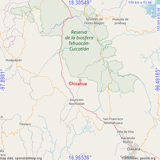
Chicahua GPS coordinates[2]
17° 38' 12.012" North, 97° 11' 41.892" West
| Map corner | latitude | longitude |
|---|---|---|
| Upper-left | 18.30549°, | -97.8981° |
| Center: | 17.63667°, | -97.19497° |
| Lower-right: | 16.96536°, | -96.49185° |
| Map W x H: | 149×149 km | = 92.6×92.6mi |
| max Lat: | 32.7° ⇑81.9% North |
| Chicahua: | 17.63667° |
| min Lat: | ⇓18.1% South 14.53588° |
| min Long | Chicahua | max Long |
| -117.105° | -97.19497° | -86.73105° |
| W 72.5%⇐ | ⇒27.5% E |
Elevation
Elevation of Chicahua is 2309 m = 7575 ft, and this is 1055.3 m = 3462 ft above average elevation for this country.
| Max E: |
3497 m = 11473 ft | 13% |
| Chicahua | 2309 m 7575 ft | |
| Avg. | 1253.7 m = 4113 ft | |
Min E: |
-1 m = -3 ft | 87% |
See also: Mexico elevation on elevation.city.
Geographical zone
Chicahua is located in North Torrid zone (between Equator and Tropic of Cancer). Distance of this Northern Tropic circle is 644.9 km =400.7 mi to North.| Distance of | km | miles | from Chicahua |
|---|---|---|---|
| North Pole | 8046 | 4999.6 | to North |
| Arctic Circle | 5440.2 | 3380.4 | to North |
| Tropic Cancer | 644.9 | 400.7 | to North |
| Equator | 1961 | 1218.5 | to South |


Nearby cities:
15 places around Chicahua: (largest is in red/bold)
• Apoala
6.4 km =4 mi,  78°
78°
• Coixtlahuaca
16.1 km =10 mi,  305°
305°
• El Fortín Alto
3.1 km =1.9 mi,  185°
185°
• Jaltepetongo
17.8 km =11.1 mi,  71°
71°
• Nativitas
15.2 km =9.4 mi,  280°
280°
• San Miguel Huautla
12.8 km =8 mi,  25°
25°
• San Miguel Huautla
13.6 km =8.5 mi, 26°
• San Pedro Coxcaltepec Cántaros
16.4 km =10.2 mi,  158°
158°
• San Pedro Jocotipac
19.1 km =11.9 mi,  39°
39°
• Santa María Apazco
10 km =6.2 mi,  91°
91°
• Santa María Chachoápam
15.5 km =9.6 mi,  217°
217°
• Santo Domingo Yanhuitlán
19.7 km =12.2 mi,  232°
232°
• Soyaltepec
13 km =8.1 mi,  247°
247°
• Texcatitlán
16 km =9.9 mi,  58°
58°
• Yucuita
16.1 km =10 mi,  209°
209°
Sources, notices
• [Note1] Compared only with cities in Mexico existing in our database
• [Src1] Map data: © OpenStreetMap contributors (CC-BY-SA)
• [Src2] Other city data from geonames.org with taken over terms of usage.
• [Src3] Geographical zone / Annual Mean Temperature by Robert A. Rohde @ Wikipedia
