San Pedro Ixcatlán geodata
San Pedro Ixcatlán (Oaxaca) is a populated place; located in Mexico in America/Mexico_City (GMT-6) time zone. With population of 3,504 people, there are 2608 cities with bigger population in this country. Compared to other cities in Mexico, 77% of cities are located further ↑North; 79.7% of cities are located further ←West and 80.3% of cities have higher elevation than San Pedro Ixcatlán. Note1


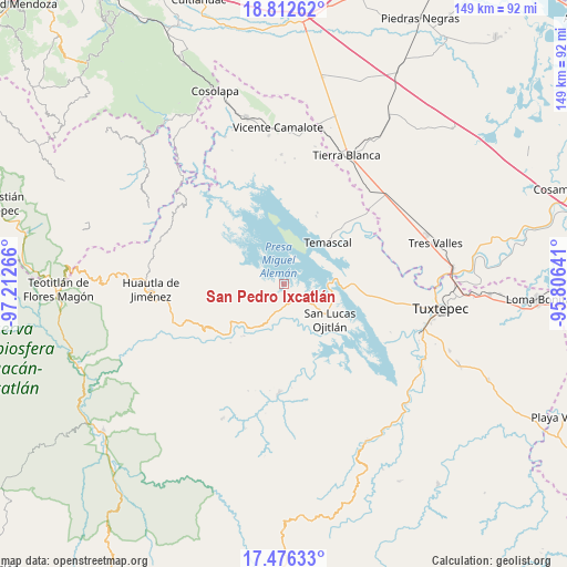
San Pedro Ixcatlán GPS coordinates[2]
18° 8' 44.7" North, 96° 30' 34.308" West
| Map corner | latitude | longitude |
|---|---|---|
| Upper-left | 18.81262°, | -97.21266° |
| Center: | 18.14575°, | -96.50953° |
| Lower-right: | 17.47633°, | -95.80641° |
| Map W x H: | 148.6×148.6 km | = 92.3×92.3mi |
| max Lat: | 32.7° ⇑77% North |
| San Pedro Ixcatlán: | 18.14575° |
| min Lat: | ⇓23% South 14.53588° |
| min Long | San Pedro Ixcat | max Long |
| -117.105° | -96.50953° | -86.73105° |
| W 79.7%⇐ | ⇒20.3% E |
Elevation
Elevation of San Pedro Ixcatlán is 91 m = 299 ft, and this is 1162.7 m = 3815 ft below average elevation for this country.
| Max E: |
3497 m = 11473 ft | 80.3% |
| Avg. | 1253.7 m = 4113 ft | |
| San Pedro Ixcatlán | 91 m = 299 ft | |
Min E: |
-1 m = -3 ft | 19.7% |
See also: Mexico elevation on elevation.city.
Geographical zone
San Pedro Ixcatlán is located in North Torrid zone (between Equator and Tropic of Cancer). Distance of this Northern Tropic circle is 588.3 km =365.6 mi to North.| Distance of | km | miles | from San Pedro Ixcatlán |
|---|---|---|---|
| North Pole | 7989.4 | 4964.4 | to North |
| Arctic Circle | 5383.6 | 3345.2 | to North |
| Tropic Cancer | 588.3 | 365.6 | to North |
| Equator | 2017.6 | 1253.7 | to South |


Nearby cities:
15 places around San Pedro Ixcatlán: (largest is in red/bold)
• Agua de Tierra (Sección la Montaña)
6.5 km =4 mi,  176°
176°
• Arroyo Grande
5.3 km =3.3 mi,  167°
167°
• Arroyo Murciélago
4 km =2.5 mi,  270°
270°
• Arroyo Tigre
7.3 km =4.5 mi,  102°
102°
• Benito Juárez II (San Martín)
5.1 km =3.2 mi, 96°
• Camino de Ixcatlán
5.1 km =3.2 mi,  194°
194°
• Cerro Quemado
7 km =4.3 mi,  277°
277°
• Colonia la Central
6.6 km =4.1 mi, 186°
• El Progreso
4.5 km =2.8 mi,  240°
240°
• Isla Soyaltepec
6.7 km =4.2 mi,  24°
24°
• La Permuta
6 km =3.7 mi,  159°
159°
• Loma San Juan
6.3 km =3.9 mi,  215°
215°
• Los Zarates
4.4 km =2.7 mi, 184°
• Piedra de Amolar
6.8 km =4.2 mi,  114°
114°
• Sección los Roques
4.6 km =2.9 mi, 174°
Sources, notices
• [Note1] Compared only with cities in Mexico existing in our database
• [Src1] Map data: © OpenStreetMap contributors (CC-BY-SA)
• [Src2] Other city data from geonames.org with taken over terms of usage.
• [Src3] Geographical zone / Annual Mean Temperature by Robert A. Rohde @ Wikipedia
