San Miguel Tlacamama geodata
San Miguel Tlacamama (Oaxaca) is a seat of a second-order administrative division; located in Mexico in America/Mexico_City (GMT-6) time zone. With population of 2,004 people, there are 4343 cities with bigger population in this country. Compared to other cities in Mexico, 94.9% of cities are located further ↑North; 62.9% of cities are located further ←West and 73.7% of cities have higher elevation than San Miguel Tlacamama. Note1


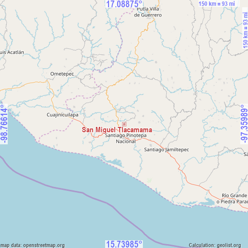
San Miguel Tlacamama GPS coordinates[2]
16° 24' 55.692" North, 98° 3' 46.836" West
| Map corner | latitude | longitude |
|---|---|---|
| Upper-left | 17.08875°, | -98.76614° |
| Center: | 16.41547°, | -98.06301° |
| Lower-right: | 15.73985°, | -97.35989° |
| Map W x H: | 150×150 km | = 93.2×93.2mi |
| max Lat: | 32.7° ⇑94.9% North |
| San Miguel Tlacamama: | 16.41547° |
| min Lat: | ⇓5.1% South 14.53588° |
| min Long | San Miguel Tlac | max Long |
| -117.105° | -98.06301° | -86.73105° |
| W 62.9%⇐ | ⇒37.1% E |
Elevation
Elevation of San Miguel Tlacamama is 265 m = 869 ft, and this is 988.7 m = 3244 ft below average elevation for this country.
| Max E: |
3497 m = 11473 ft | 73.7% |
| Avg. | 1253.7 m = 4113 ft | |
| San Miguel Tlacamama | 265 m = 869 ft | |
Min E: |
-1 m = -3 ft | 26.3% |
See also: Mexico elevation on elevation.city.
Geographical zone
San Miguel Tlacamama is located in North Torrid zone (between Equator and Tropic of Cancer). Distance of this Northern Tropic circle is 780.7 km =485.1 mi to North.| Distance of | km | miles | from San Miguel Tlacamama |
|---|---|---|---|
| North Pole | 8181.8 | 5083.9 | to North |
| Arctic Circle | 5575.9 | 3464.7 | to North |
| Tropic Cancer | 780.7 | 485.1 | to North |
| Equator | 1825.2 | 1134.1 | to South |


Nearby cities:
15 places around San Miguel Tlacamama: (largest is in red/bold)
• Chuparrosa
5.2 km =3.2 mi,  17°
17°
• Fraccionamiento San Isidro
5.9 km =3.7 mi,  183°
183°
• Lo de Candela
8.1 km =5 mi,  255°
255°
• Mancuernas
5.8 km =3.6 mi,  240°
240°
• Pinotepa Nacional
8.4 km =5.2 mi,  172°
172°
• Pinotepa de Don Luis
9.3 km =5.8 mi,  81°
81°
• Rancho Viejo
13.5 km =8.4 mi,  128°
128°
• San José Yutatuyaa
4.3 km =2.7 mi,  29°
29°
• San Juan Colorado
12.6 km =7.8 mi,  66°
66°
• San Juan Jicayán
8.6 km =5.3 mi,  38°
38°
• San Pedro Atoyac
11.7 km =7.3 mi, 44°
• San Pedro Jicayán
6.6 km =4.1 mi,  52°
52°
• Santa María Jicaltepec
4.5 km =2.8 mi,  152°
152°
• Santiago Jicayán
9 km =5.6 mi, 38°
• Yutandayoo
4.9 km =3 mi,  342°
342°
Sources, notices
• [Note1] Compared only with cities in Mexico existing in our database
• [Src1] Map data: © OpenStreetMap contributors (CC-BY-SA)
• [Src2] Other city data from geonames.org with taken over terms of usage.
• [Src3] Geographical zone / Annual Mean Temperature by Robert A. Rohde @ Wikipedia
