San Pablo Huixtepec geodata
San Pablo Huixtepec (Oaxaca) is a seat of a second-order administrative division; located in Mexico in America/Mexico_City (GMT-6) time zone. With population of 8,786 people, there are 1082 cities with bigger population in this country. Compared to other cities in Mexico, 91.4% of cities are located further ↑North; 77.5% of cities are located further ←West and 51% of cities have lower elevation than San Pablo Huixtepec. Note1


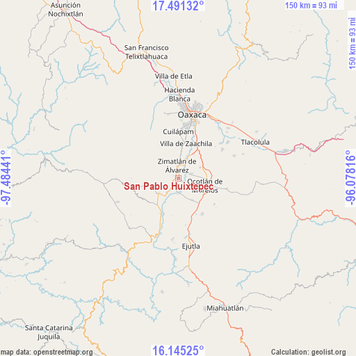
San Pablo Huixtepec GPS coordinates[2]
16° 49' 10.128" North, 96° 46' 52.608" West
| Map corner | latitude | longitude |
|---|---|---|
| Upper-left | 17.49132°, | -97.48441° |
| Center: | 16.81948°, | -96.78128° |
| Lower-right: | 16.14525°, | -96.07816° |
| Map W x H: | 149.7×149.7 km | = 93×93mi |
| max Lat: | 32.7° ⇑91.4% North |
| San Pablo Huixtepec: | 16.81948° |
| min Lat: | ⇓8.6% South 14.53588° |
| min Long | San Pablo Huixt | max Long |
| -117.105° | -96.78128° | -86.73105° |
| W 77.5%⇐ | ⇒22.5% E |
Elevation
Elevation of San Pablo Huixtepec is 1485 m = 4872 ft, and this is 231.3 m = 759 ft above average elevation for this country.
| Max E: |
3497 m = 11473 ft | 49% |
| San Pablo Huixtepec | 1485 m 4872 ft | |
| Avg. | 1253.7 m = 4113 ft | |
Min E: |
-1 m = -3 ft | 51% |
See also: Mexico elevation on elevation.city.
Geographical zone
San Pablo Huixtepec is located in North Torrid zone (between Equator and Tropic of Cancer). Distance of this Northern Tropic circle is 735.8 km =457.2 mi to North.| Distance of | km | miles | from San Pablo Huixtepec |
|---|---|---|---|
| North Pole | 8136.9 | 5056 | to North |
| Arctic Circle | 5531 | 3436.8 | to North |
| Tropic Cancer | 735.8 | 457.2 | to North |
| Equator | 1870.2 | 1162.1 | to South |


Nearby cities:
15 places around San Pablo Huixtepec: (largest is in red/bold)
• Asunción Ocotlán
9 km =5.6 mi,  135°
135°
• Ciénega de Zimatlán
8.4 km =5.2 mi,  10°
10°
• Emiliano Zapata
8.5 km =5.3 mi,  220°
220°
• San Jerónimo Zegache
4.8 km =3 mi,  43°
43°
• San José Guelatová de Díaz
3.4 km =2.1 mi,  186°
186°
• San Nicolás Quialana
2.7 km =1.7 mi, 5°
• Santa Ana Zegache
5.8 km =3.6 mi,  70°
70°
• Santa Catarina Quiané
8.2 km =5.1 mi,  31°
31°
• Santa Gertrudis
4.3 km =2.7 mi,  208°
208°
• Santa Inés Yatzeche
2.9 km =1.8 mi,  119°
119°
• Santa María Vigallo
5.6 km =3.5 mi,  318°
318°
• Santiago Apostol
6.7 km =4.2 mi,  105°
105°
• Tejas de Morelos
6.8 km =4.2 mi,  168°
168°
• Valdeflores
7.5 km =4.7 mi, 217°
• Zimatlán de Álvarez
5.6 km =3.5 mi,  356°
356°
Sources, notices
• [Note1] Compared only with cities in Mexico existing in our database
• [Src1] Map data: © OpenStreetMap contributors (CC-BY-SA)
• [Src2] Other city data from geonames.org with taken over terms of usage.
• [Src3] Geographical zone / Annual Mean Temperature by Robert A. Rohde @ Wikipedia
