Santa Ana Zegache geodata
Santa Ana Zegache (Oaxaca) is a seat of a second-order administrative division; located in Mexico in America/Mexico_City (GMT-6) time zone. With population of 2,617 people, there are 3388 cities with bigger population in this country. Compared to other cities in Mexico, 91.2% of cities are located further ↑North; 78.1% of cities are located further ←West and 51.1% of cities have lower elevation than Santa Ana Zegache. Note1


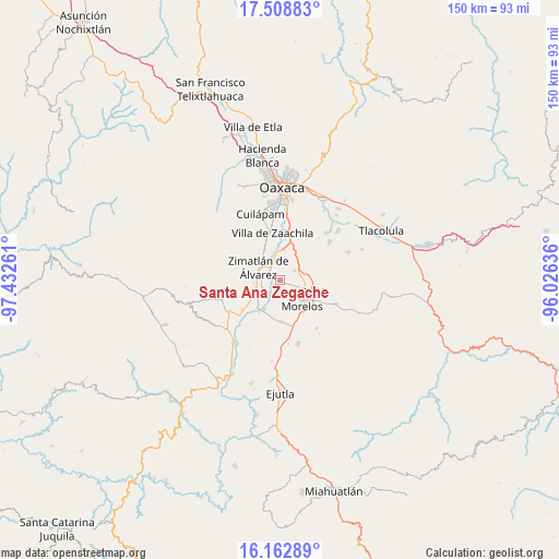
Santa Ana Zegache GPS coordinates[2]
16° 50' 13.416" North, 96° 43' 46.128" West
| Map corner | latitude | longitude |
|---|---|---|
| Upper-left | 17.50883°, | -97.43261° |
| Center: | 16.83706°, | -96.72948° |
| Lower-right: | 16.16289°, | -96.02636° |
| Map W x H: | 149.7×149.7 km | = 93×93mi |
| max Lat: | 32.7° ⇑91.2% North |
| Santa Ana Zegache: | 16.83706° |
| min Lat: | ⇓8.8% South 14.53588° |
| min Long | Santa Ana Zegac | max Long |
| -117.105° | -96.72948° | -86.73105° |
| W 78.1%⇐ | ⇒21.9% E |
Elevation
Elevation of Santa Ana Zegache is 1490 m = 4888 ft, and this is 236.3 m = 775 ft above average elevation for this country.
| Max E: |
3497 m = 11473 ft | 48.9% |
| Santa Ana Zegache | 1490 m 4888 ft | |
| Avg. | 1253.7 m = 4113 ft | |
Min E: |
-1 m = -3 ft | 51.1% |
See also: Mexico elevation on elevation.city.
Geographical zone
Santa Ana Zegache is located in North Torrid zone (between Equator and Tropic of Cancer). Distance of this Northern Tropic circle is 733.8 km =456 mi to North.| Distance of | km | miles | from Santa Ana Zegache |
|---|---|---|---|
| North Pole | 8135 | 5054.9 | to North |
| Arctic Circle | 5529.1 | 3435.6 | to North |
| Tropic Cancer | 733.8 | 456 | to North |
| Equator | 1872.1 | 1163.3 | to South |


Nearby cities:
15 places around Santa Ana Zegache: (largest is in red/bold)
• Ciénega de Zimatlán
7.5 km =4.7 mi,  327°
327°
• Ocotlán de Morelos
7.7 km =4.8 mi,  130°
130°
• San Antonino Castillo Velasco
6.4 km =4 mi, 128°
• San Jacinto Chilateca
4.8 km =3 mi,  85°
85°
• San Jerónimo Zegache
2.7 km =1.7 mi,  305°
305°
• San Juan Chilateca
6.5 km =4 mi,  96°
96°
• San Martín Tilcajete
4.5 km =2.8 mi,  55°
55°
• San Nicolás Quialana
5.3 km =3.3 mi,  277°
277°
• San Pablo Huixtepec
5.8 km =3.6 mi,  250°
250°
• San Pedro Guegorexe
7.3 km =4.5 mi, 57°
• Santa Catarina Quiané
5.2 km =3.2 mi,  346°
346°
• Santa Inés Yatzeche
4.5 km =2.8 mi,  221°
221°
• Santiago Apostol
3.8 km =2.4 mi,  165°
165°
• Santo Tomás Jalieza
6.3 km =3.9 mi,  82°
82°
• Zimatlán de Álvarez
6.9 km =4.3 mi,  301°
301°
Sources, notices
• [Note1] Compared only with cities in Mexico existing in our database
• [Src1] Map data: © OpenStreetMap contributors (CC-BY-SA)
• [Src2] Other city data from geonames.org with taken over terms of usage.
• [Src3] Geographical zone / Annual Mean Temperature by Robert A. Rohde @ Wikipedia
