Chalco geodata
Chalco (State of Mexico) is a seat of a second-order administrative division; located in Mexico in America/Mexico_City (GMT-6) time zone. With population of 168,720 people, there are 94 cities with bigger population in this country. Compared to other cities in Mexico, 59.6% of cities are located further ↑North; 52% of cities are located further ←West and 84.2% of cities have lower elevation than Chalco. Note1


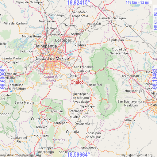
Chalco GPS coordinates[2]
19° 15' 42.264" North, 98° 53' 51.9" West
| Map corner | latitude | longitude |
|---|---|---|
| Upper-left | 19.92415°, | -99.60088° |
| Center: | 19.26174°, | -98.89775° |
| Lower-right: | 18.59664°, | -98.19463° |
| Map W x H: | 147.6×147.6 km | = 91.7×91.7mi |
| max Lat: | 32.7° ⇑59.6% North |
| Chalco: | 19.26174° |
| min Lat: | ⇓40.4% South 14.53588° |
| min Long | Chalco | max Long |
| -117.105° | -98.89775° | -86.73105° |
| W 52%⇐ | ⇒48% E |
Elevation
Elevation of Chalco is 2245 m = 7365 ft, and this is 991.3 m = 3252 ft above average elevation for this country.
| Max E: |
3497 m = 11473 ft | 15.8% |
| Chalco | 2245 m 7365 ft | |
| Avg. | 1253.7 m = 4113 ft | |
Min E: |
-1 m = -3 ft | 84.2% |
See also: Chalco elevation on elevation.city.
Geographical zone
Chalco is located in North Torrid zone (between Equator and Tropic of Cancer). Distance of this Northern Tropic circle is 464.2 km =288.4 mi to North.| Distance of | km | miles | from Chalco |
|---|---|---|---|
| North Pole | 7865.4 | 4887.3 | to North |
| Arctic Circle | 5259.5 | 3268.1 | to North |
| Tropic Cancer | 464.2 | 288.4 | to North |
| Equator | 2141.7 | 1330.8 | to South |


Nearby cities:
15 places around Chalco: (largest is in red/bold)
• Barrio de Guadalupe
4.9 km =3 mi,  225°
225°
• Cocotitlán
4.6 km =2.9 mi,  133°
133°
• Colonia San José
6 km =3.7 mi,  180°
180°
• Ex-Hacienda de Guadalupe
5.8 km =3.6 mi,  106°
106°
• Ixtapaluca
6.2 km =3.9 mi,  14°
14°
• La Candelaria Tlapala
5.8 km =3.6 mi, 114°
• Los Reyes Acatlixhuayán
6.1 km =3.8 mi,  164°
164°
• San Buenaventura
5.8 km =3.6 mi,  38°
38°
• San Gregorio Cuautzingo
4.2 km =2.6 mi,  93°
93°
• San Lucas Amalinalco
3.7 km =2.3 mi,  74°
74°
• San Marcos Huixtoco
5.3 km =3.3 mi, 42°
• San Mateo Huitzilzingo
4.6 km =2.9 mi,  218°
218°
• San Pablo Atlazalpan
5 km =3.1 mi,  191°
191°
• Xico
5.7 km =3.5 mi,  279°
279°
• Zula
4.7 km =2.9 mi,  169°
169°
Sources, notices
• [Note1] Compared only with cities in Mexico existing in our database
• [Src1] Map data: © OpenStreetMap contributors (CC-BY-SA)
• [Src2] Other city data from geonames.org with taken over terms of usage.
• [Src3] Geographical zone / Annual Mean Temperature by Robert A. Rohde @ Wikipedia
