Buenavista geodata
Buenavista (State of Mexico) is a populated place; located in Mexico in America/Mexico_City (GMT-6) time zone. With population of 2,496 people, there are 3539 cities with bigger population in this country. Compared to other cities in Mexico, 65.9% of cities are located further ↑North; 59.6% of cities are located further →East and 78.7% of cities have lower elevation than Buenavista. Note1


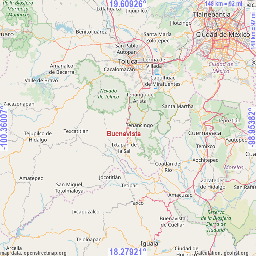
Buenavista GPS coordinates[2]
18° 56' 44.016" North, 99° 39' 24.984" West
| Map corner | latitude | longitude |
|---|---|---|
| Upper-left | 19.60926°, | -100.36007° |
| Center: | 18.94556°, | -99.65694° |
| Lower-right: | 18.27921°, | -98.95382° |
| Map W x H: | 147.9×147.9 km | = 91.9×91.9mi |
| max Lat: | 32.7° ⇑65.9% North |
| Buenavista: | 18.94556° |
| min Lat: | ⇓34.1% South 14.53588° |
| min Long | Buenavista | max Long |
| -117.105° | -99.65694° | -86.73105° |
| W 40.4%⇐ | ⇒59.6% E |
Elevation
Elevation of Buenavista is 2104 m = 6903 ft, and this is 850.3 m = 2790 ft above average elevation for this country.
| Max E: |
3497 m = 11473 ft | 21.3% |
| Buenavista | 2104 m 6903 ft | |
| Avg. | 1253.7 m = 4113 ft | |
Min E: |
-1 m = -3 ft | 78.7% |
See also: Mexico elevation on elevation.city.
Geographical zone
Buenavista is located in North Torrid zone (between Equator and Tropic of Cancer). Distance of this Northern Tropic circle is 499.4 km =310.3 mi to North.| Distance of | km | miles | from Buenavista |
|---|---|---|---|
| North Pole | 7900.5 | 4909.1 | to North |
| Arctic Circle | 5294.6 | 3289.9 | to North |
| Tropic Cancer | 499.4 | 310.3 | to North |
| Equator | 2106.5 | 1308.9 | to South |


Nearby cities:
15 places around Buenavista: (largest is in red/bold)
• Coxcacoaco
3.2 km =2 mi,  71°
71°
• Ejido de San Mateo Coapexco
1.6 km =1 mi,  76°
76°
• El Islote
2.5 km =1.6 mi,  355°
355°
• Jesús Carranza (Rancho de Jesús)
2.8 km =1.7 mi,  90°
90°
• La Joya
3 km =1.9 mi,  8°
8°
• La Lagunilla
4.6 km =2.9 mi,  116°
116°
• San Felipe
1.4 km =0.9 mi,  169°
169°
• San Francisco
1.1 km =0.7 mi, 67°
• San Lucas
3.6 km =2.2 mi,  353°
353°
• San Mateo Coapexco
3.3 km =2.1 mi,  302°
302°
• Santa Ana Ixtlahuatzingo (Santa Ana)
4.5 km =2.8 mi,  51°
51°
• Santiago Oxtotitlán
2.1 km =1.3 mi,  326°
326°
• Totolmajac
3.7 km =2.3 mi,  235°
235°
• Villa Guerrero
2.5 km =1.6 mi,  43°
43°
• Zacango
4.5 km =2.8 mi,  285°
285°
Sources, notices
• [Note1] Compared only with cities in Mexico existing in our database
• [Src1] Map data: © OpenStreetMap contributors (CC-BY-SA)
• [Src2] Other city data from geonames.org with taken over terms of usage.
• [Src3] Geographical zone / Annual Mean Temperature by Robert A. Rohde @ Wikipedia
