San Mateo Sosola geodata
San Mateo Sosola (Oaxaca) is a populated place; located in Mexico in America/Mexico_City (GMT-6) time zone. With population of 582 people, there are 14734 cities with bigger population in this country. Compared to other cities in Mexico, 84.2% of cities are located further ↑North; 73.4% of cities are located further ←West and 77.8% of cities have lower elevation than San Mateo Sosola. Note1


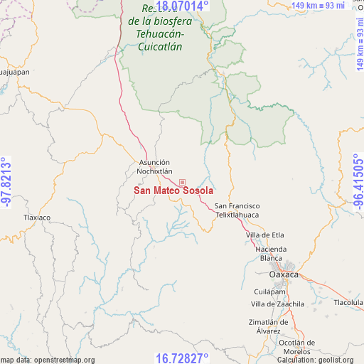
San Mateo Sosola GPS coordinates[2]
17° 24' 1.584" North, 97° 7' 5.412" West
| Map corner | latitude | longitude |
|---|---|---|
| Upper-left | 18.07014°, | -97.8213° |
| Center: | 17.40044°, | -97.11817° |
| Lower-right: | 16.72827°, | -96.41505° |
| Map W x H: | 149.2×149.2 km | = 92.7×92.7mi |
| max Lat: | 32.7° ⇑84.2% North |
| San Mateo Sosola: | 17.40044° |
| min Lat: | ⇓15.8% South 14.53588° |
| min Long | San Mateo Sosol | max Long |
| -117.105° | -97.11817° | -86.73105° |
| W 73.4%⇐ | ⇒26.6% E |
Elevation
Elevation of San Mateo Sosola is 2085 m = 6841 ft, and this is 831.3 m = 2727 ft above average elevation for this country.
| Max E: |
3497 m = 11473 ft | 22.2% |
| San Mateo Sosola | 2085 m 6841 ft | |
| Avg. | 1253.7 m = 4113 ft | |
Min E: |
-1 m = -3 ft | 77.8% |
See also: Mexico elevation on elevation.city.
Geographical zone
San Mateo Sosola is located in North Torrid zone (between Equator and Tropic of Cancer). Distance of this Northern Tropic circle is 671.2 km =417.1 mi to North.| Distance of | km | miles | from San Mateo Sosola |
|---|---|---|---|
| North Pole | 8072.3 | 5015.9 | to North |
| Arctic Circle | 5466.4 | 3396.7 | to North |
| Tropic Cancer | 671.2 | 417.1 | to North |
| Equator | 1934.7 | 1202.2 | to South |


Nearby cities:
15 places around San Mateo Sosola: (largest is in red/bold)
• Asunción Nochixtlán
13.2 km =8.2 mi,  299°
299°
• Magdalena Jaltepec
13.9 km =8.6 mi,  231°
231°
• Magdalena Zahuatlán
11.7 km =7.3 mi,  264°
264°
• San Andrés Sinaxtla
19.1 km =11.9 mi,  293°
293°
• San Francisco Chindúa
20.9 km =13 mi,  278°
278°
• San Francisco Jaltepetongo
15.6 km =9.7 mi, 264°
• San Jerónimo Sosola
9.8 km =6.1 mi,  112°
112°
• San Juan Sayultepec
18.6 km =11.6 mi, 288°
• San Mateo Etlatongo
16.6 km =10.3 mi, 276°
• San Miguel Tecomatlán
16 km =9.9 mi,  267°
267°
• San Pedro Coxcaltepec Cántaros
11.2 km =7 mi,  349°
349°
• Santiago Huauclilla
7.5 km =4.7 mi,  40°
40°
• Santiago Tenango
14.7 km =9.1 mi,  124°
124°
• Santiago Tillo
22.5 km =14 mi, 287°
• Yucuita
20.2 km =12.6 mi,  307°
307°
Sources, notices
• [Note1] Compared only with cities in Mexico existing in our database
• [Src1] Map data: © OpenStreetMap contributors (CC-BY-SA)
• [Src2] Other city data from geonames.org with taken over terms of usage.
• [Src3] Geographical zone / Annual Mean Temperature by Robert A. Rohde @ Wikipedia
