Santiago Huauclilla geodata
Santiago Huauclilla (Oaxaca) is a seat of a second-order administrative division; located in Mexico in America/Mexico_City (GMT-6) time zone. With population of 233 people, there are 16882 cities with bigger population in this country. Compared to other cities in Mexico, 83.6% of cities are located further ↑North; 73.9% of cities are located further ←West and 77% of cities have lower elevation than Santiago Huauclilla. Note1


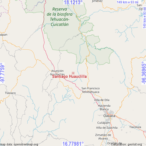
Santiago Huauclilla GPS coordinates[2]
17° 27' 6.444" North, 97° 4' 21.972" West
| Map corner | latitude | longitude |
|---|---|---|
| Upper-left | 18.1213°, | -97.7759° |
| Center: | 17.45179°, | -97.07277° |
| Lower-right: | 16.77981°, | -96.36965° |
| Map W x H: | 149.2×149.2 km | = 92.7×92.7mi |
| max Lat: | 32.7° ⇑83.6% North |
| Santiago Huauclilla: | 17.45179° |
| min Lat: | ⇓16.4% South 14.53588° |
| min Long | Santiago Huaucl | max Long |
| -117.105° | -97.07277° | -86.73105° |
| W 73.9%⇐ | ⇒26.1% E |
Elevation
Elevation of Santiago Huauclilla is 2067 m = 6781 ft, and this is 813.3 m = 2668 ft above average elevation for this country.
| Max E: |
3497 m = 11473 ft | 23% |
| Santiago Huauclilla | 2067 m 6781 ft | |
| Avg. | 1253.7 m = 4113 ft | |
Min E: |
-1 m = -3 ft | 77% |
See also: Mexico elevation on elevation.city.
Geographical zone
Santiago Huauclilla is located in North Torrid zone (between Equator and Tropic of Cancer). Distance of this Northern Tropic circle is 665.5 km =413.5 mi to North.| Distance of | km | miles | from Santiago Huauclilla |
|---|---|---|---|
| North Pole | 8066.6 | 5012.4 | to North |
| Arctic Circle | 5460.7 | 3393.1 | to North |
| Tropic Cancer | 665.5 | 413.5 | to North |
| Equator | 1940.5 | 1205.8 | to South |


Nearby cities:
15 places around Santiago Huauclilla: (largest is in red/bold)
• Asunción Nochixtlán
16.3 km =10.1 mi,  272°
272°
• El Fortín Alto
21.9 km =13.6 mi,  322°
322°
• Magdalena Jaltepec
21.3 km =13.2 mi,  227°
227°
• Magdalena Zahuatlán
17.8 km =11.1 mi,  247°
247°
• San Andrés Sinaxtla
22.4 km =13.9 mi, 274°
• San Francisco Jaltepetongo
21.7 km =13.5 mi, 250°
• San Jerónimo Sosola
10.3 km =6.4 mi,  155°
155°
• San Mateo Etlatongo
21.7 km =13.5 mi,  259°
259°
• San Mateo Sosola
7.5 km =4.7 mi,  220°
220°
• San Miguel Tecomatlán
21.7 km =13.5 mi, 252°
• San Pedro Coxcaltepec Cántaros
8.7 km =5.4 mi,  307°
307°
• Santa María Apazco
20.5 km =12.7 mi,  351°
351°
• Santiago Nacaltepec
17.5 km =10.9 mi,  68°
68°
• Santiago Tenango
15.9 km =9.9 mi,  152°
152°
• Yucuita
21.9 km =13.6 mi,  287°
287°
Sources, notices
• [Note1] Compared only with cities in Mexico existing in our database
• [Src1] Map data: © OpenStreetMap contributors (CC-BY-SA)
• [Src2] Other city data from geonames.org with taken over terms of usage.
• [Src3] Geographical zone / Annual Mean Temperature by Robert A. Rohde @ Wikipedia
