Soledad Macín Chico geodata
Soledad Macín Chico (Oaxaca) is a populated place; located in Mexico in America/Mexico_City (GMT-6) time zone. With population of 689 people, there are 12616 cities with bigger population in this country. Compared to other cities in Mexico, 78% of cities are located further ↑North; 81.3% of cities are located further ←West and 83.8% of cities have higher elevation than Soledad Macín Chico. Note1


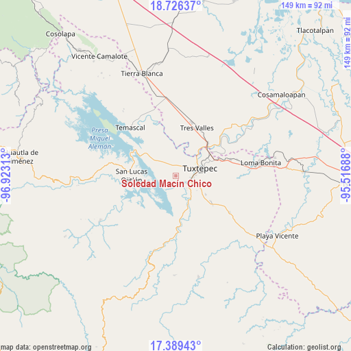
Soledad Macín Chico GPS coordinates[2]
18° 3' 33.012" North, 96° 13' 12" West
| Map corner | latitude | longitude |
|---|---|---|
| Upper-left | 18.72637°, | -96.92313° |
| Center: | 18.05917°, | -96.22° |
| Lower-right: | 17.38943°, | -95.51688° |
| Map W x H: | 148.7×148.7 km | = 92.4×92.4mi |
| max Lat: | 32.7° ⇑78% North |
| Soledad Macín Chico: | 18.05917° |
| min Lat: | ⇓22% South 14.53588° |
| min Long | Soledad Macín | max Long |
| -117.105° | -96.22° | -86.73105° |
| W 81.3%⇐ | ⇒18.7% E |
Elevation
Elevation of Soledad Macín Chico is 53 m = 174 ft, and this is 1200.7 m = 3939 ft below average elevation for this country.
| Max E: |
3497 m = 11473 ft | 83.8% |
| Avg. | 1253.7 m = 4113 ft | |
| Soledad Macín Chico | 53 m = 174 ft | |
Min E: |
-1 m = -3 ft | 16.2% |
See also: Mexico elevation on elevation.city.
Geographical zone
Soledad Macín Chico is located in North Torrid zone (between Equator and Tropic of Cancer). Distance of this Northern Tropic circle is 597.9 km =371.5 mi to North.| Distance of | km | miles | from Soledad Macín Chico |
|---|---|---|---|
| North Pole | 7999.1 | 4970.4 | to North |
| Arctic Circle | 5393.2 | 3351.2 | to North |
| Tropic Cancer | 597.9 | 371.5 | to North |
| Equator | 2008 | 1247.7 | to South |


Nearby cities:
15 places around Soledad Macín Chico: (largest is in red/bold)
• Arroyo Choápam
11.9 km =7.4 mi,  146°
146°
• Buenos Aires el Apompo
12 km =7.5 mi,  321°
321°
• Camelia Roja
3.7 km =2.3 mi,  159°
159°
• El Camarón
5.9 km =3.7 mi,  18°
18°
• El Porvenir
10.7 km =6.6 mi,  1°
1°
• Fortino J. Pinacho
9.1 km =5.7 mi, 147°
• Las Peñitas
12.4 km =7.7 mi,  43°
43°
• Macín Chico
5.6 km =3.5 mi,  280°
280°
• Mata de Caña
11.3 km =7 mi,  105°
105°
• Mazín Grande
11.4 km =7.1 mi,  303°
303°
• Paso Canoa
5.5 km =3.4 mi,  200°
200°
• San Isidro
10.6 km =6.6 mi, 17°
• Santa Ursula
6 km =3.7 mi, 195°
• Sebastopol
5.8 km =3.6 mi,  119°
119°
• Tuxtepec
10.5 km =6.5 mi,  72°
72°
Sources, notices
• [Note1] Compared only with cities in Mexico existing in our database
• [Src1] Map data: © OpenStreetMap contributors (CC-BY-SA)
• [Src2] Other city data from geonames.org with taken over terms of usage.
• [Src3] Geographical zone / Annual Mean Temperature by Robert A. Rohde @ Wikipedia
