San Jerónimo Axochitlán geodata
San Jerónimo Axochitlán (Puebla) is a populated place; located in Mexico in America/Mexico_City (GMT-6) time zone. With population of 1,088 people, there are 8000 cities with bigger population in this country. Compared to other cities in Mexico, 75.2% of cities are located further ↑North; 71.8% of cities are located further ←West and 58.5% of cities have higher elevation than San Jerónimo Axochitlán. Note1
Current local time in San Jerónimo Axochitlán:
06:51 AM, WednesdayDifference from your time zone: hours


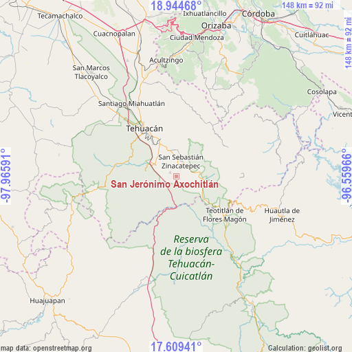
San Jerónimo Axochitlán GPS coordinates[2]
18° 16' 41.988" North, 97° 15' 46.008" West
| Map corner | latitude | longitude |
|---|---|---|
| Upper-left | 18.94468°, | -97.96591° |
| Center: | 18.27833°, | -97.26278° |
| Lower-right: | 17.60941°, | -96.55966° |
| Map W x H: | 148.5×148.5 km | = 92.3×92.3mi |
| max Lat: | 32.7° ⇑75.2% North |
| San Jerónimo Axochitlán: | 18.27833° |
| min Lat: | ⇓24.8% South 14.53588° |
| min Long | San Jerónimo A | max Long |
| -117.105° | -97.26278° | -86.73105° |
| W 71.8%⇐ | ⇒28.2% E |
Elevation
Elevation of San Jerónimo Axochitlán is 1081 m = 3547 ft, and this is 172.7 m = 567 ft below average elevation for this country.
| Max E: |
3497 m = 11473 ft | 58.5% |
| Avg. | 1253.7 m = 4113 ft | |
| San Jerónimo Axochitlán | 1081 m = 3547 ft | |
Min E: |
-1 m = -3 ft | 41.5% |
See also: Mexico elevation on elevation.city.
Geographical zone
San Jerónimo Axochitlán is located in North Torrid zone (between Equator and Tropic of Cancer). Distance of this Northern Tropic circle is 573.6 km =356.4 mi to North.| Distance of | km | miles | from San Jerónimo Axochitlán |
|---|---|---|---|
| North Pole | 7974.7 | 4955.2 | to North |
| Arctic Circle | 5368.8 | 3336 | to North |
| Tropic Cancer | 573.6 | 356.4 | to North |
| Equator | 2032.4 | 1262.9 | to South |


Nearby cities:
15 places around San Jerónimo Axochitlán: (largest is in red/bold)
• Ajalpan
11.2 km =7 mi,  2°
2°
• Altepexi
10.9 km =6.8 mi,  339°
339°
• Axuxco
7.9 km =4.9 mi,  132°
132°
• Calipan
10.6 km =6.6 mi,  79°
79°
• Cinco de Mayo
14.9 km =9.3 mi,  357°
357°
• Coxcatlán
11.9 km =7.4 mi,  96°
96°
• Miahuatlán
3 km =1.9 mi,  299°
299°
• San Gabriel Chilac
10.3 km =6.4 mi, 300°
• San José Buena Vista
14.1 km =8.8 mi, 357°
• San Juan Atzingo
13.2 km =8.2 mi,  279°
279°
• San Mateo Tlacoxcalco
6.8 km =4.2 mi, 277°
• San Miguel
16.5 km =10.3 mi,  334°
334°
• San Pedro Tetitlán
6.7 km =4.2 mi,  251°
251°
• Santa Cruz Acapa
15.6 km =9.7 mi, 334°
• Zinacatepec
6.6 km =4.1 mi,  15°
15°
Sources, notices
• [Note1] Compared only with cities in Mexico existing in our database
• [Src1] Map data: © OpenStreetMap contributors (CC-BY-SA)
• [Src2] Other city data from geonames.org with taken over terms of usage.
• [Src3] Geographical zone / Annual Mean Temperature by Robert A. Rohde @ Wikipedia
