Calipan geodata
Calipan (Puebla) is a populated place; located in Mexico in America/Mexico_City (GMT-6) time zone. With population of 4,099 people, there are 2231 cities with bigger population in this country. Compared to other cities in Mexico, 74.9% of cities are located further ↑North; 72.8% of cities are located further ←West and 56.5% of cities have higher elevation than Calipan. Note1


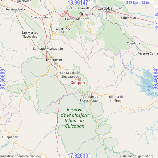
Calipan GPS coordinates[2]
18° 17' 42.684" North, 97° 9' 49.536" West
| Map corner | latitude | longitude |
|---|---|---|
| Upper-left | 18.96147°, | -97.86689° |
| Center: | 18.29519°, | -97.16376° |
| Lower-right: | 17.62633°, | -96.46064° |
| Map W x H: | 148.5×148.5 km | = 92.3×92.3mi |
| max Lat: | 32.7° ⇑74.9% North |
| Calipan: | 18.29519° |
| min Lat: | ⇓25.1% South 14.53588° |
| min Long | Calipan | max Long |
| -117.105° | -97.16376° | -86.73105° |
| W 72.8%⇐ | ⇒27.2% E |
Elevation
Elevation of Calipan is 1140 m = 3740 ft, and this is 113.7 m = 373 ft below average elevation for this country.
| Max E: |
3497 m = 11473 ft | 56.5% |
| Avg. | 1253.7 m = 4113 ft | |
| Calipan | 1140 m = 3740 ft | |
Min E: |
-1 m = -3 ft | 43.5% |
See also: Mexico elevation on elevation.city.
Geographical zone
Calipan is located in North Torrid zone (between Equator and Tropic of Cancer). Distance of this Northern Tropic circle is 571.7 km =355.2 mi to North.| Distance of | km | miles | from Calipan |
|---|---|---|---|
| North Pole | 7972.8 | 4954.1 | to North |
| Arctic Circle | 5366.9 | 3334.8 | to North |
| Tropic Cancer | 571.7 | 355.2 | to North |
| Equator | 2034.2 | 1264 | to South |


Nearby cities:
15 places around Calipan: (largest is in red/bold)
• Acatepec
15.9 km =9.9 mi,  57°
57°
• Ajalpan
13.7 km =8.5 mi,  312°
312°
• Axuxco
8.5 km =5.3 mi,  212°
212°
• Boca del Monte
13.8 km =8.6 mi,  40°
40°
• Cacaloc
9.4 km =5.8 mi,  46°
46°
• Chichiltepec
9.9 km =6.2 mi,  128°
128°
• Cinco Señores
12.3 km =7.6 mi, 46°
• Coxcatlán
3.4 km =2.1 mi,  156°
156°
• Miahuatlán
13.1 km =8.1 mi,  268°
268°
• Ocotlamanic
7.8 km =4.8 mi,  65°
65°
• San Jerónimo Axochitlán
10.6 km =6.6 mi,  259°
259°
• Tecoltepec
9.6 km =6 mi, 69°
• Xitlama
15.5 km =9.6 mi,  86°
86°
• Zinacatepec
9.8 km =6.1 mi,  297°
297°
• Zoquitlanzacualco
14.2 km =8.8 mi,  75°
75°
Sources, notices
• [Note1] Compared only with cities in Mexico existing in our database
• [Src1] Map data: © OpenStreetMap contributors (CC-BY-SA)
• [Src2] Other city data from geonames.org with taken over terms of usage.
• [Src3] Geographical zone / Annual Mean Temperature by Robert A. Rohde @ Wikipedia
