Axuxco geodata
Axuxco (Puebla) is a populated place; located in Mexico in America/Mexico_City (GMT-6) time zone. With population of 1,598 people, there are 5410 cities with bigger population in this country. Compared to other cities in Mexico, 75.8% of cities are located further ↑North; 72.4% of cities are located further ←West and 60.4% of cities have higher elevation than Axuxco. Note1


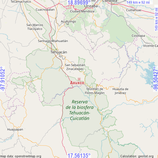
Axuxco GPS coordinates[2]
18° 13' 49.62" North, 97° 12' 26.604" West
| Map corner | latitude | longitude |
|---|---|---|
| Upper-left | 18.89699°, | -97.91052° |
| Center: | 18.23045°, | -97.20739° |
| Lower-right: | 17.56135°, | -96.50427° |
| Map W x H: | 148.5×148.5 km | = 92.3×92.3mi |
| max Lat: | 32.7° ⇑75.8% North |
| Axuxco: | 18.23045° |
| min Lat: | ⇓24.2% South 14.53588° |
| min Long | Axuxco | max Long |
| -117.105° | -97.20739° | -86.73105° |
| W 72.4%⇐ | ⇒27.6% E |
Elevation
Elevation of Axuxco is 977 m = 3205 ft, and this is 276.7 m = 908 ft below average elevation for this country.
| Max E: |
3497 m = 11473 ft | 60.4% |
| Avg. | 1253.7 m = 4113 ft | |
| Axuxco | 977 m = 3205 ft | |
Min E: |
-1 m = -3 ft | 39.6% |
See also: Mexico elevation on elevation.city.
Geographical zone
Axuxco is located in North Torrid zone (between Equator and Tropic of Cancer). Distance of this Northern Tropic circle is 578.9 km =359.7 mi to North.| Distance of | km | miles | from Axuxco |
|---|---|---|---|
| North Pole | 7980 | 4958.5 | to North |
| Arctic Circle | 5374.1 | 3339.3 | to North |
| Tropic Cancer | 578.9 | 359.7 | to North |
| Equator | 2027 | 1259.5 | to South |


Nearby cities:
15 places around Axuxco: (largest is in red/bold)
• Ajalpan
17.4 km =10.8 mi,  341°
341°
• Cacaloc
17.8 km =11.1 mi,  39°
39°
• Calipan
8.5 km =5.3 mi,  32°
32°
• Chichiltepec
12.4 km =7.7 mi,  85°
85°
• Coxcatlán
7.2 km =4.5 mi,  55°
55°
• Ignacio Mejía
17.7 km =11 mi,  146°
146°
• Miahuatlán
10.9 km =6.8 mi,  308°
308°
• Nanahuatípam
13.8 km =8.6 mi,  140°
140°
• Ocotlamanic
15.6 km =9.7 mi,  48°
48°
• San Jerónimo Axochitlán
7.9 km =4.9 mi, 312°
• San José Tilapa
13.4 km =8.3 mi,  123°
123°
• San Mateo Tlacoxcalco
14 km =8.7 mi,  296°
296°
• San Pedro Tetitlán
12.6 km =7.8 mi,  284°
284°
• Tecoltepec
17.2 km =10.7 mi, 52°
• Zinacatepec
12.3 km =7.6 mi, 340°
Sources, notices
• [Note1] Compared only with cities in Mexico existing in our database
• [Src1] Map data: © OpenStreetMap contributors (CC-BY-SA)
• [Src2] Other city data from geonames.org with taken over terms of usage.
• [Src3] Geographical zone / Annual Mean Temperature by Robert A. Rohde @ Wikipedia
