Coxcatlán geodata
Coxcatlán (Puebla) is a seat of a second-order administrative division; located in Mexico in America/Mexico_City (GMT-6) time zone. With population of 6,300 people, there are 1477 cities with bigger population in this country. Compared to other cities in Mexico, 75.3% of cities are located further ↑North; 73% of cities are located further ←West and 55.9% of cities have higher elevation than Coxcatlán. Note1


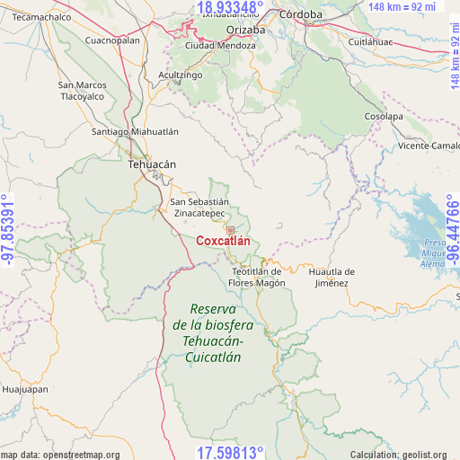
Coxcatlán GPS coordinates[2]
18° 16' 1.524" North, 97° 9' 2.808" West
| Map corner | latitude | longitude |
|---|---|---|
| Upper-left | 18.93348°, | -97.85391° |
| Center: | 18.26709°, | -97.15078° |
| Lower-right: | 17.59813°, | -96.44766° |
| Map W x H: | 148.5×148.5 km | = 92.3×92.3mi |
| max Lat: | 32.7° ⇑75.3% North |
| Coxcatlán: | 18.26709° |
| min Lat: | ⇓24.7% South 14.53588° |
| min Long | Coxcatlán | max Long |
| -117.105° | -97.15078° | -86.73105° |
| W 73%⇐ | ⇒27% E |
Elevation
Elevation of Coxcatlán is 1163 m = 3816 ft, and this is 90.7 m = 298 ft below average elevation for this country.
| Max E: |
3497 m = 11473 ft | 55.9% |
| Avg. | 1253.7 m = 4113 ft | |
| Coxcatlán | 1163 m = 3816 ft | |
Min E: |
-1 m = -3 ft | 44.1% |
See also: Mexico elevation on elevation.city.
Geographical zone
Coxcatlán is located in North Torrid zone (between Equator and Tropic of Cancer). Distance of this Northern Tropic circle is 574.8 km =357.2 mi to North.| Distance of | km | miles | from Coxcatlán |
|---|---|---|---|
| North Pole | 7976 | 4956.1 | to North |
| Arctic Circle | 5370.1 | 3336.8 | to North |
| Tropic Cancer | 574.8 | 357.2 | to North |
| Equator | 2031.1 | 1262.1 | to South |


Nearby cities:
15 places around Coxcatlán: (largest is in red/bold)
• Axuxco
7.2 km =4.5 mi,  235°
235°
• Cacaloc
11 km =6.8 mi,  29°
29°
• Calipan
3.4 km =2.1 mi,  336°
336°
• Chichiltepec
7 km =4.3 mi,  115°
115°
• Cinco Señores
13.8 km =8.6 mi, 33°
• Miahuatlán
14.7 km =9.1 mi,  280°
280°
• Nanahuatípam
15 km =9.3 mi,  169°
169°
• Ocotlamanic
8.5 km =5.3 mi,  42°
42°
• San Jerónimo Axochitlán
11.9 km =7.4 mi, 276°
• San José Tilapa
12.6 km =7.8 mi,  155°
155°
• Segunda Sección
15.4 km =9.6 mi,  82°
82°
• Tecoltepec
10 km =6.2 mi,  49°
49°
• Xitlama
14.6 km =9.1 mi,  73°
73°
• Zinacatepec
12.6 km =7.8 mi,  306°
306°
• Zoquitlanzacualco
14.1 km =8.8 mi,  61°
61°
Sources, notices
• [Note1] Compared only with cities in Mexico existing in our database
• [Src1] Map data: © OpenStreetMap contributors (CC-BY-SA)
• [Src2] Other city data from geonames.org with taken over terms of usage.
• [Src3] Geographical zone / Annual Mean Temperature by Robert A. Rohde @ Wikipedia
