Tetipanapa geodata
Tetipanapa (Puebla) is a populated place; located in Mexico in America/Mexico_City (GMT-6) time zone. With population of 889 people, there are 9811 cities with bigger population in this country. Compared to other cities in Mexico, 54.8% of cities are located further ↑North; 69.1% of cities are located further ←West and 88.3% of cities have lower elevation than Tetipanapa. Note1


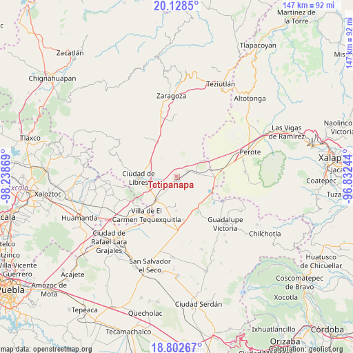
Tetipanapa GPS coordinates[2]
19° 28' 0.984" North, 97° 32' 8.016" West
| Map corner | latitude | longitude |
|---|---|---|
| Upper-left | 20.1285°, | -98.23869° |
| Center: | 19.46694°, | -97.53556° |
| Lower-right: | 18.80267°, | -96.83244° |
| Map W x H: | 147.4×147.4 km | = 91.6×91.6mi |
| max Lat: | 32.7° ⇑54.8% North |
| Tetipanapa: | 19.46694° |
| min Lat: | ⇓45.2% South 14.53588° |
| min Long | Tetipanapa | max Long |
| -117.105° | -97.53556° | -86.73105° |
| W 69.1%⇐ | ⇒30.9% E |
Elevation
Elevation of Tetipanapa is 2350 m = 7710 ft, and this is 1096.3 m = 3597 ft above average elevation for this country.
| Max E: |
3497 m = 11473 ft | 11.7% |
| Tetipanapa | 2350 m 7710 ft | |
| Avg. | 1253.7 m = 4113 ft | |
Min E: |
-1 m = -3 ft | 88.3% |
See also: Mexico elevation on elevation.city.
Geographical zone
Tetipanapa is located in North Torrid zone (between Equator and Tropic of Cancer). Distance of this Northern Tropic circle is 441.4 km =274.3 mi to North.| Distance of | km | miles | from Tetipanapa |
|---|---|---|---|
| North Pole | 7842.5 | 4873.1 | to North |
| Arctic Circle | 5236.7 | 3253.9 | to North |
| Tropic Cancer | 441.4 | 274.3 | to North |
| Equator | 2164.5 | 1345 | to South |


Nearby cities:
15 places around Tetipanapa: (largest is in red/bold)
• Allende
10.3 km =6.4 mi,  321°
321°
• El Fuerte de la Unión
4.8 km =3 mi,  213°
213°
• Guadalupe Sarabia
13.4 km =8.3 mi,  57°
57°
• Itzoteno
11.7 km =7.3 mi,  118°
118°
• Miravalles
14 km =8.7 mi,  181°
181°
• Nuevo México
8.7 km =5.4 mi,  261°
261°
• Oriental
13.5 km =8.4 mi,  221°
221°
• Progreso
15 km =9.3 mi,  279°
279°
• San Andrés Payuca
10.8 km =6.7 mi,  307°
307°
• San Antonio Virreyes
12.4 km =7.7 mi,  239°
239°
• Techachalco
14.2 km =8.8 mi,  132°
132°
• Tepeyehualco de Hidalgo
5.1 km =3.2 mi, 61°
• Texcal
13.6 km =8.5 mi,  1°
1°
• Xaltipanapa
11.8 km =7.3 mi,  19°
19°
• Álvaro Obregón (San Francisco)
15.2 km =9.4 mi, 260°
Sources, notices
• [Note1] Compared only with cities in Mexico existing in our database
• [Src1] Map data: © OpenStreetMap contributors (CC-BY-SA)
• [Src2] Other city data from geonames.org with taken over terms of usage.
• [Src3] Geographical zone / Annual Mean Temperature by Robert A. Rohde @ Wikipedia
