Sahé geodata
Sahé (Yucatán) is a populated place; located in Mexico in America/Merida (GMT-6) time zone. With population of 507 people, there are 16589 cities with bigger population in this country. Compared to other cities in Mexico, 75.2% of cities are located further ↓South; 98.2% of cities are located further ←West and 94% of cities have higher elevation than Sahé. Note1


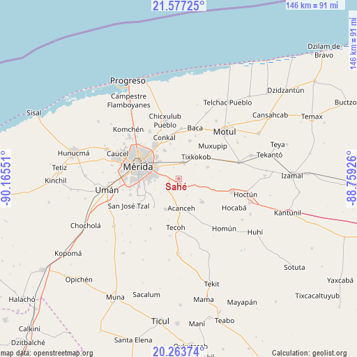
Sahé GPS coordinates[2]
20° 55' 18.948" North, 89° 27' 44.568" West
| Map corner | latitude | longitude |
|---|---|---|
| Upper-left | 21.57725°, | -90.16551° |
| Center: | 20.92193°, | -89.46238° |
| Lower-right: | 20.26374°, | -88.75926° |
| Map W x H: | 146×146.1 km | = 90.7×90.8mi |
| max Lat: | 32.7° ⇑24.8% North |
| Sahé: | 20.92193° |
| min Lat: | ⇓75.2% South 14.53588° |
| min Long | Sahé | max Long |
| -117.105° | -89.46238° | -86.73105° |
| W 98.2%⇐ | ⇒1.8% E |
Elevation
Elevation of Sahé is 15 m = 49 ft, and this is 1238.7 m = 4064 ft below average elevation for this country.
| Max E: |
3497 m = 11473 ft | 94% |
| Avg. | 1253.7 m = 4113 ft | |
| Sahé | 15 m = 49 ft | |
Min E: |
-1 m = -3 ft | 6% |
See also: Mexico elevation on elevation.city.
Geographical zone
Sahé is located in North Torrid zone (between Equator and Tropic of Cancer). Distance of this Northern Tropic circle is 279.6 km =173.7 mi to North.| Distance of | km | miles | from Sahé |
|---|---|---|---|
| North Pole | 7680.8 | 4772.6 | to North |
| Arctic Circle | 5074.9 | 3153.4 | to North |
| Tropic Cancer | 279.6 | 173.7 | to North |
| Equator | 2326.3 | 1445.5 | to South |


Nearby cities:
15 places around Sahé: (largest is in red/bold)
• Acanceh
12.2 km =7.6 mi,  175°
175°
• Canícab
7.5 km =4.7 mi,  155°
155°
• Chochoh
8 km =5 mi,  356°
356°
• Kanasín
10.1 km =6.3 mi,  278°
278°
• Nolo
10.6 km =6.6 mi,  22°
22°
• Oncan
5.1 km =3.2 mi,  334°
334°
• Petectunich
9 km =5.6 mi,  189°
189°
• San Antonio Millet
8.8 km =5.5 mi,  49°
49°
• San Antonio Tehuitz
6.5 km =4 mi,  247°
247°
• Subinkancab
9.4 km =5.8 mi,  229°
229°
• Tepich Carrillo
6.2 km =3.9 mi,  216°
216°
• Teya
6.2 km =3.9 mi,  285°
285°
• Ticopó
4.3 km =2.7 mi,  148°
148°
• Tixkokob
11.4 km =7.1 mi,  38°
38°
• Tixpehual
6.5 km =4 mi, 18°
Sources, notices
• [Note1] Compared only with cities in Mexico existing in our database
• [Src1] Map data: © OpenStreetMap contributors (CC-BY-SA)
• [Src2] Other city data from geonames.org with taken over terms of usage.
• [Src3] Geographical zone / Annual Mean Temperature by Robert A. Rohde @ Wikipedia
