Kanasín geodata
Kanasín (Yucatán) is a seat of a second-order administrative division; located in Mexico in America/Merida (GMT-6) time zone. With population of 77,240 people, there are 159 cities with bigger population in this country. Compared to other cities in Mexico, 75.4% of cities are located further ↓South; 98% of cities are located further ←West and 95.7% of cities have higher elevation than Kanasín. Note1


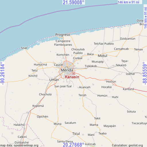
Kanasín GPS coordinates[2]
20° 56' 5.352" North, 89° 33' 31.356" West
| Map corner | latitude | longitude |
|---|---|---|
| Upper-left | 21.59008°, | -90.26184° |
| Center: | 20.93482°, | -89.55871° |
| Lower-right: | 20.27668°, | -88.85559° |
| Map W x H: | 146×146 km | = 90.7×90.7mi |
| max Lat: | 32.7° ⇑24.6% North |
| Kanasín: | 20.93482° |
| min Lat: | ⇓75.4% South 14.53588° |
| min Long | Kanasín | max Long |
| -117.105° | -89.55871° | -86.73105° |
| W 98%⇐ | ⇒2% E |
Elevation
Elevation of Kanasín is 12 m = 39 ft, and this is 1241.7 m = 4074 ft below average elevation for this country.
| Max E: |
3497 m = 11473 ft | 95.7% |
| Avg. | 1253.7 m = 4113 ft | |
| Kanasín | 12 m = 39 ft | |
Min E: |
-1 m = -3 ft | 4.3% |
See also: Kanasín elevation on elevation.city.
Geographical zone
Kanasín is located in North Torrid zone (between Equator and Tropic of Cancer). Distance of this Northern Tropic circle is 278.2 km =172.9 mi to North.| Distance of | km | miles | from Kanasín |
|---|---|---|---|
| North Pole | 7679.3 | 4771.7 | to North |
| Arctic Circle | 5073.4 | 3152.5 | to North |
| Tropic Cancer | 278.2 | 172.9 | to North |
| Equator | 2327.7 | 1446.4 | to South |


Nearby cities:
15 places around Kanasín: (largest is in red/bold)
• Chochoh
11.5 km =7.1 mi,  55°
55°
• Cholul
12 km =7.5 mi,  359°
359°
• Leona Vicario
5.2 km =3.2 mi,  237°
237°
• Mérida
7.5 km =4.7 mi,  306°
306°
• Oncan
8.4 km =5.2 mi,  67°
67°
• Sahé
10.1 km =6.3 mi,  98°
98°
• San Antonio Tehuitz
5.6 km =3.5 mi,  134°
134°
• San Pedro Chimay
8.1 km =5 mi,  195°
195°
• Santa Cruz Palomeque
11.5 km =7.1 mi, 238°
• Sitpach
10.9 km =6.8 mi,  20°
20°
• Subinkancab
8 km =5 mi,  159°
159°
• Tahdzibichen
6.8 km =4.2 mi,  216°
216°
• Tepich Carrillo
9 km =5.6 mi,  135°
135°
• Teya
4 km =2.5 mi,  87°
87°
• Xmatkuíl
10.8 km =6.7 mi, 219°
Sources, notices
• [Note1] Compared only with cities in Mexico existing in our database
• [Src1] Map data: © OpenStreetMap contributors (CC-BY-SA)
• [Src2] Other city data from geonames.org with taken over terms of usage.
• [Src3] Geographical zone / Annual Mean Temperature by Robert A. Rohde @ Wikipedia
