Teya geodata
Teya (Yucatán) is a populated place; located in Mexico in America/Merida (GMT-6) time zone. With population of 566 people, there are 15096 cities with bigger population in this country. Compared to other cities in Mexico, 75.5% of cities are located further ↓South; 98.1% of cities are located further ←West and 97% of cities have higher elevation than Teya. Note1


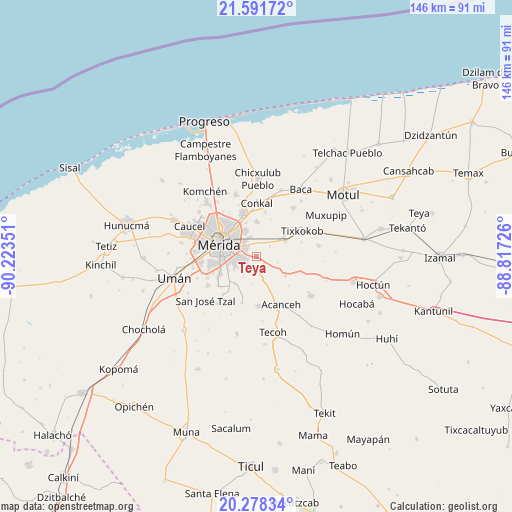
Teya GPS coordinates[2]
20° 56' 11.292" North, 89° 31' 13.368" West
| Map corner | latitude | longitude |
|---|---|---|
| Upper-left | 21.59172°, | -90.22351° |
| Center: | 20.93647°, | -89.52038° |
| Lower-right: | 20.27834°, | -88.81726° |
| Map W x H: | 146×146 km | = 90.7×90.7mi |
| max Lat: | 32.7° ⇑24.5% North |
| Teya: | 20.93647° |
| min Lat: | ⇓75.5% South 14.53588° |
| min Long | Teya | max Long |
| -117.105° | -89.52038° | -86.73105° |
| W 98.1%⇐ | ⇒1.9% E |
Elevation
Elevation of Teya is 10 m = 33 ft, and this is 1243.7 m = 4080 ft below average elevation for this country.
| Max E: |
3497 m = 11473 ft | 97% |
| Avg. | 1253.7 m = 4113 ft | |
| Teya | 10 m = 33 ft | |
Min E: |
-1 m = -3 ft | 3% |
See also: Mexico elevation on elevation.city.
Geographical zone
Teya is located in North Torrid zone (between Equator and Tropic of Cancer). Distance of this Northern Tropic circle is 278 km =172.7 mi to North.| Distance of | km | miles | from Teya |
|---|---|---|---|
| North Pole | 7679.1 | 4771.6 | to North |
| Arctic Circle | 5073.3 | 3152.4 | to North |
| Tropic Cancer | 278 | 172.7 | to North |
| Equator | 2327.9 | 1446.5 | to South |


Nearby cities:
15 places around Teya: (largest is in red/bold)
• Chochoh
8.4 km =5.2 mi,  40°
40°
• Kanasín
4 km =2.5 mi,  267°
267°
• Leona Vicario
8.9 km =5.5 mi,  250°
250°
• Mérida
10.9 km =6.8 mi,  293°
293°
• Oncan
4.8 km =3 mi,  51°
51°
• Petectunich
11.5 km =7.1 mi,  156°
156°
• Sahé
6.2 km =3.9 mi,  105°
105°
• San Antonio Tehuitz
4.1 km =2.5 mi,  180°
180°
• San Pedro Chimay
10.1 km =6.3 mi,  217°
217°
• Sitpach
10 km =6.2 mi,  359°
359°
• Subinkancab
7.8 km =4.8 mi,  188°
188°
• Tahdzibichen
9.8 km =6.1 mi,  234°
234°
• Tepich Carrillo
7 km =4.3 mi, 160°
• Ticopó
9.8 km =6.1 mi,  122°
122°
• Tixpehual
9.3 km =5.8 mi,  60°
60°
Sources, notices
• [Note1] Compared only with cities in Mexico existing in our database
• [Src1] Map data: © OpenStreetMap contributors (CC-BY-SA)
• [Src2] Other city data from geonames.org with taken over terms of usage.
• [Src3] Geographical zone / Annual Mean Temperature by Robert A. Rohde @ Wikipedia
