Ticopó geodata
Ticopó (Yucatán) is a populated place; located in Mexico in America/Merida (GMT-6) time zone. With population of 1,660 people, there are 5235 cities with bigger population in this country. Compared to other cities in Mexico, 74.7% of cities are located further ↓South; 98.2% of cities are located further ←West and 93% of cities have higher elevation than Ticopó. Note1


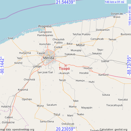
Ticopó GPS coordinates[2]
20° 53' 20.148" North, 89° 26' 27.852" West
| Map corner | latitude | longitude |
|---|---|---|
| Upper-left | 21.54439°, | -90.1442° |
| Center: | 20.88893°, | -89.44107° |
| Lower-right: | 20.23059°, | -88.73795° |
| Map W x H: | 146.1×146.1 km | = 90.8×90.8mi |
| max Lat: | 32.7° ⇑25.3% North |
| Ticopó: | 20.88893° |
| min Lat: | ⇓74.7% South 14.53588° |
| min Long | Ticopó | max Long |
| -117.105° | -89.44107° | -86.73105° |
| W 98.2%⇐ | ⇒1.8% E |
Elevation
Elevation of Ticopó is 17 m = 56 ft, and this is 1236.7 m = 4057 ft below average elevation for this country.
| Max E: |
3497 m = 11473 ft | 93% |
| Avg. | 1253.7 m = 4113 ft | |
| Ticopó | 17 m = 56 ft | |
Min E: |
-1 m = -3 ft | 7% |
See also: Mexico elevation on elevation.city.
Geographical zone
Ticopó is located in North Torrid zone (between Equator and Tropic of Cancer). Distance of this Northern Tropic circle is 283.3 km =176 mi to North.| Distance of | km | miles | from Ticopó |
|---|---|---|---|
| North Pole | 7684.4 | 4774.9 | to North |
| Arctic Circle | 5078.5 | 3155.6 | to North |
| Tropic Cancer | 283.3 | 176 | to North |
| Equator | 2322.6 | 1443.2 | to South |


Nearby cities:
15 places around Ticopó: (largest is in red/bold)
• Acanceh
8.6 km =5.3 mi,  188°
188°
• Canícab
3.3 km =2.1 mi,  163°
163°
• Chochoh
12 km =7.5 mi,  346°
346°
• Holactun
11.7 km =7.3 mi,  96°
96°
• Oncan
9.4 km =5.8 mi,  331°
331°
• Petectunich
6.4 km =4 mi,  214°
214°
• Sahé
4.3 km =2.7 mi, 328°
• San Antonio Millet
10.4 km =6.5 mi,  25°
25°
• San Antonio Tehuitz
8.3 km =5.2 mi,  278°
278°
• Seyé
9.3 km =5.8 mi,  129°
129°
• Subinkancab
9.7 km =6 mi,  255°
255°
• Tepich Carrillo
6.1 km =3.8 mi, 257°
• Teya
9.8 km =6.1 mi,  302°
302°
• Timucuy
11.6 km =7.2 mi,  220°
220°
• Tixpehual
9.8 km =6.1 mi,  359°
359°
Sources, notices
• [Note1] Compared only with cities in Mexico existing in our database
• [Src1] Map data: © OpenStreetMap contributors (CC-BY-SA)
• [Src2] Other city data from geonames.org with taken over terms of usage.
• [Src3] Geographical zone / Annual Mean Temperature by Robert A. Rohde @ Wikipedia
