San Juan Volador geodata
San Juan Volador (Veracruz) is a populated place; located in Mexico in America/Mexico_City (GMT-6) time zone. With population of 1,725 people, there are 5031 cities with bigger population in this country. Compared to other cities in Mexico, 75.4% of cities are located further ↑North; 85.2% of cities are located further ←West and 79.4% of cities have higher elevation than San Juan Volador. Note1


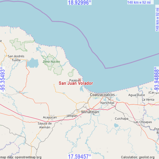
San Juan Volador GPS coordinates[2]
18° 15' 48.78" North, 94° 39' 6.48" West
| Map corner | latitude | longitude |
|---|---|---|
| Upper-left | 18.92996°, | -95.35493° |
| Center: | 18.26355°, | -94.6518° |
| Lower-right: | 17.59457°, | -93.94868° |
| Map W x H: | 148.5×148.5 km | = 92.3×92.3mi |
| max Lat: | 32.7° ⇑75.4% North |
| San Juan Volador: | 18.26355° |
| min Lat: | ⇓24.6% South 14.53588° |
| min Long | San Juan Volado | max Long |
| -117.105° | -94.6518° | -86.73105° |
| W 85.2%⇐ | ⇒14.8% E |
Elevation
Elevation of San Juan Volador is 104 m = 341 ft, and this is 1149.7 m = 3772 ft below average elevation for this country.
| Max E: |
3497 m = 11473 ft | 79.4% |
| Avg. | 1253.7 m = 4113 ft | |
| San Juan Volador | 104 m = 341 ft | |
Min E: |
-1 m = -3 ft | 20.6% |
See also: Mexico elevation on elevation.city.
Geographical zone
San Juan Volador is located in North Torrid zone (between Equator and Tropic of Cancer). Distance of this Northern Tropic circle is 575.2 km =357.4 mi to North.| Distance of | km | miles | from San Juan Volador |
|---|---|---|---|
| North Pole | 7976.3 | 4956.2 | to North |
| Arctic Circle | 5370.5 | 3337.1 | to North |
| Tropic Cancer | 575.2 | 357.4 | to North |
| Equator | 2030.7 | 1261.8 | to South |


Nearby cities:
15 places around San Juan Volador: (largest is in red/bold)
• El Naranjo
18.9 km =11.7 mi,  222°
222°
• Encino Amarillo
15.1 km =9.4 mi,  281°
281°
• Fraccionamiento Ciudad Olmeca
16.4 km =10.2 mi,  140°
140°
• Huazuntlán
19.1 km =11.9 mi,  231°
231°
• Ixhuapán
18.3 km =11.4 mi,  237°
237°
• Jicacal
6.9 km =4.3 mi, 142°
• Las Barrillas
10.5 km =6.5 mi,  145°
145°
• Lomas de Barrillas
18.4 km =11.4 mi,  134°
134°
• Minzapan
16 km =9.9 mi,  209°
209°
• Pajapan
4.2 km =2.6 mi,  268°
268°
• Puerto Esmeralda
19.1 km =11.9 mi, 132°
• Residencial las Olas
18.5 km =11.5 mi, 150°
• Tatahuicapan
11.7 km =7.3 mi,  260°
260°
• Tonalapa
19.6 km =12.2 mi, 229°
• Ursulo Galván
19.8 km =12.3 mi,  316°
316°
Sources, notices
• [Note1] Compared only with cities in Mexico existing in our database
• [Src1] Map data: © OpenStreetMap contributors (CC-BY-SA)
• [Src2] Other city data from geonames.org with taken over terms of usage.
• [Src3] Geographical zone / Annual Mean Temperature by Robert A. Rohde @ Wikipedia
