Pajapan geodata
Pajapan (Veracruz) is a seat of a second-order administrative division; located in Mexico in America/Mexico_City (GMT-6) time zone. With population of 8,434 people, there are 1128 cities with bigger population in this country. Compared to other cities in Mexico, 75.4% of cities are located further ↑North; 85.2% of cities are located further ←West and 75.7% of cities have higher elevation than Pajapan. Note1


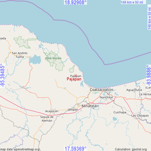
Pajapan GPS coordinates[2]
18° 15' 45.612" North, 94° 41' 30.192" West
| Map corner | latitude | longitude |
|---|---|---|
| Upper-left | 18.92908°, | -95.39485° |
| Center: | 18.26267°, | -94.69172° |
| Lower-right: | 17.59369°, | -93.9886° |
| Map W x H: | 148.5×148.5 km | = 92.3×92.3mi |
| max Lat: | 32.7° ⇑75.4% North |
| Pajapan: | 18.26267° |
| min Lat: | ⇓24.6% South 14.53588° |
| min Long | Pajapan | max Long |
| -117.105° | -94.69172° | -86.73105° |
| W 85.2%⇐ | ⇒14.8% E |
Elevation
Elevation of Pajapan is 198 m = 650 ft, and this is 1055.7 m = 3464 ft below average elevation for this country.
| Max E: |
3497 m = 11473 ft | 75.7% |
| Avg. | 1253.7 m = 4113 ft | |
| Pajapan | 198 m = 650 ft | |
Min E: |
-1 m = -3 ft | 24.3% |
See also: Mexico elevation on elevation.city.
Geographical zone
Pajapan is located in North Torrid zone (between Equator and Tropic of Cancer). Distance of this Northern Tropic circle is 575.3 km =357.5 mi to North.| Distance of | km | miles | from Pajapan |
|---|---|---|---|
| North Pole | 7976.4 | 4956.3 | to North |
| Arctic Circle | 5370.6 | 3337.1 | to North |
| Tropic Cancer | 575.3 | 357.5 | to North |
| Equator | 2030.6 | 1261.8 | to South |


Nearby cities:
15 places around Pajapan: (largest is in red/bold)
• Amamaloya
17.6 km =10.9 mi,  224°
224°
• El Naranjo
16.3 km =10.1 mi,  211°
211°
• Encino Amarillo
11 km =6.8 mi,  285°
285°
• Huazuntlán
15.9 km =9.9 mi, 222°
• Ixhuapán
14.9 km =9.3 mi,  229°
229°
• Jicacal
10 km =6.2 mi,  122°
122°
• Las Barrillas
13.3 km =8.3 mi,  129°
129°
• Mecayapan
16.2 km =10.1 mi,  252°
252°
• Minzapan
14.3 km =8.9 mi,  195°
195°
• Ocotal Chico
17.8 km =11.1 mi,  268°
268°
• Piedra Labrada
17.7 km =11 mi,  330°
330°
• San Juan Volador
4.2 km =2.6 mi,  88°
88°
• Tatahuicapan
7.6 km =4.7 mi,  256°
256°
• Tonalapa
16.5 km =10.3 mi, 220°
• Ursulo Galván
17.3 km =10.7 mi, 327°
Sources, notices
• [Note1] Compared only with cities in Mexico existing in our database
• [Src1] Map data: © OpenStreetMap contributors (CC-BY-SA)
• [Src2] Other city data from geonames.org with taken over terms of usage.
• [Src3] Geographical zone / Annual Mean Temperature by Robert A. Rohde @ Wikipedia
