Ursulo Galván geodata
Ursulo Galván (Veracruz) is a populated place; located in Mexico in America/Mexico_City (GMT-6) time zone. With population of 617 people, there are 13976 cities with bigger population in this country. Compared to other cities in Mexico, 73.9% of cities are located further ↑North; 85% of cities are located further ←West and 77.6% of cities have higher elevation than Ursulo Galván. Note1


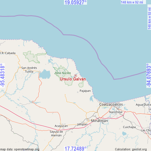
Ursulo Galván GPS coordinates[2]
18° 23' 36.132" North, 94° 46' 48.18" West
| Map corner | latitude | longitude |
|---|---|---|
| Upper-left | 19.05927°, | -95.48318° |
| Center: | 18.39337°, | -94.78005° |
| Lower-right: | 17.72489°, | -94.07693° |
| Map W x H: | 148.4×148.4 km | = 92.2×92.2mi |
| max Lat: | 32.7° ⇑73.9% North |
| Ursulo Galván: | 18.39337° |
| min Lat: | ⇓26.1% South 14.53588° |
| min Long | Ursulo Galván | max Long |
| -117.105° | -94.78005° | -86.73105° |
| W 85%⇐ | ⇒15% E |
Elevation
Elevation of Ursulo Galván is 139 m = 456 ft, and this is 1114.7 m = 3657 ft below average elevation for this country.
| Max E: |
3497 m = 11473 ft | 77.6% |
| Avg. | 1253.7 m = 4113 ft | |
| Ursulo Galván | 139 m = 456 ft | |
Min E: |
-1 m = -3 ft | 22.4% |
See also: Mexico elevation on elevation.city.
Geographical zone
Ursulo Galván is located in North Torrid zone (between Equator and Tropic of Cancer). Distance of this Northern Tropic circle is 560.8 km =348.5 mi to North.| Distance of | km | miles | from Ursulo Galván |
|---|---|---|---|
| North Pole | 7961.9 | 4947.3 | to North |
| Arctic Circle | 5356 | 3328.1 | to North |
| Tropic Cancer | 560.8 | 348.5 | to North |
| Equator | 2045.2 | 1270.8 | to South |


Nearby cities:
15 places around Ursulo Galván: (largest is in red/bold)
• Buenavista
24.5 km =15.2 mi,  221°
221°
• Colonia la Magdalena
23.4 km =14.5 mi,  252°
252°
• El Tulín
24.5 km =15.2 mi,  228°
228°
• Encino Amarillo
11.6 km =7.2 mi,  186°
186°
• Ixhuapán
24.2 km =15 mi,  184°
184°
• Los Arrecifes
17.5 km =10.9 mi,  332°
332°
• Mecayapan
20.2 km =12.6 mi,  197°
197°
• Ocotal Chico
17.3 km =10.7 mi,  209°
209°
• Ocozotepec
20.3 km =12.6 mi, 222°
• Pajapan
17.3 km =10.7 mi,  147°
147°
• Piedra Labrada
1.1 km =0.7 mi,  38°
38°
• San Fernando
17.7 km =11 mi, 218°
• San Juan Volador
19.8 km =12.3 mi,  136°
136°
• Soteapan
20.3 km =12.6 mi, 208°
• Tatahuicapan
16.5 km =10.3 mi,  173°
173°
Sources, notices
• [Note1] Compared only with cities in Mexico existing in our database
• [Src1] Map data: © OpenStreetMap contributors (CC-BY-SA)
• [Src2] Other city data from geonames.org with taken over terms of usage.
• [Src3] Geographical zone / Annual Mean Temperature by Robert A. Rohde @ Wikipedia
