Progreso geodata
Progreso (Yucatán) is a seat of a second-order administrative division; located in Mexico in America/Merida (GMT-6) time zone. With population of 37,369 people, there are 276 cities with bigger population in this country. Compared to other cities in Mexico, 79.9% of cities are located further ↓South; 97.9% of cities are located further ←West and 99.8% of cities have higher elevation than Progreso. Note1


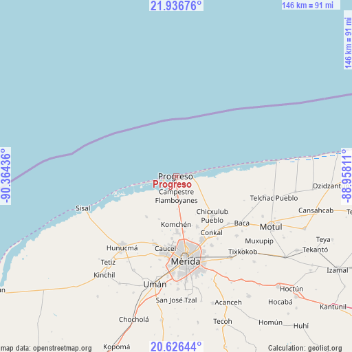
Progreso GPS coordinates[2]
21° 16' 59.016" North, 89° 39' 40.428" West
| Map corner | latitude | longitude |
|---|---|---|
| Upper-left | 21.93676°, | -90.36436° |
| Center: | 21.28306°, | -89.66123° |
| Lower-right: | 20.62644°, | -88.95811° |
| Map W x H: | 145.7×145.7 km | = 90.5×90.5mi |
| max Lat: | 32.7° ⇑20.1% North |
| Progreso: | 21.28306° |
| min Lat: | ⇓79.9% South 14.53588° |
| min Long | Progreso | max Long |
| -117.105° | -89.66123° | -86.73105° |
| W 97.9%⇐ | ⇒2.1% E |
Elevation
Elevation of Progreso is 3 m = 10 ft, and this is 1250.7 m = 4103 ft below average elevation for this country.
| Max E: |
3497 m = 11473 ft | 99.8% |
| Avg. | 1253.7 m = 4113 ft | |
| Progreso | 3 m = 10 ft | |
Min E: |
-1 m = -3 ft | 0.2% |
See also: Mexico elevation on elevation.city.
Geographical zone
Progreso is located in North Torrid zone (between Equator and Tropic of Cancer). Distance of this Northern Tropic circle is 239.5 km =148.8 mi to North.| Distance of | km | miles | from Progreso |
|---|---|---|---|
| North Pole | 7640.6 | 4747.6 | to North |
| Arctic Circle | 5034.7 | 3128.4 | to North |
| Tropic Cancer | 239.5 | 148.8 | to North |
| Equator | 2366.5 | 1470.5 | to South |


Nearby cities:
15 places around Progreso: (largest is in red/bold)
• Campestre Flamboyanes
8.1 km =5 mi,  177°
177°
• Chablekal
22.5 km =14 mi,  157°
157°
• Chelem
8.3 km =5.2 mi,  259°
259°
• Chicxulub Pueblo
22.2 km =13.8 mi,  137°
137°
• Chicxulub Puerto
6.6 km =4.1 mi,  77°
77°
• Chuburná
14.5 km =9 mi, 258°
• Cosgaya
21 km =13 mi,  192°
192°
• Ixil
23.6 km =14.7 mi,  128°
128°
• Komchén
20 km =12.4 mi, 180°
• La Ceiba
21.6 km =13.4 mi,  171°
171°
• San Ignacio
13.7 km =8.5 mi, 177°
• Sierra Papacal
18.9 km =11.7 mi,  202°
202°
• Tamanché
16.1 km =10 mi, 172°
• Xcanatún
23.2 km =14.4 mi, 172°
• Xcunyá
17.4 km =10.8 mi, 163°
In other languages:
- In Spanish: Progreso de Castro
- In German: Progreso de Castro
- In Russian: Прогресо
Sources, notices
• [Note1] Compared only with cities in Mexico existing in our database
• [Src1] Map data: © OpenStreetMap contributors (CC-BY-SA)
• [Src2] Other city data from geonames.org with taken over terms of usage.
• [Src3] Geographical zone / Annual Mean Temperature by Robert A. Rohde @ Wikipedia
