Ixil geodata
Ixil (Yucatán) is a seat of a second-order administrative division; located in Mexico in America/Merida (GMT-6) time zone. With population of 3,728 people, there are 2463 cities with bigger population in this country. Compared to other cities in Mexico, 78.6% of cities are located further ↓South; 98.1% of cities are located further ←West and 98.7% of cities have higher elevation than Ixil. Note1


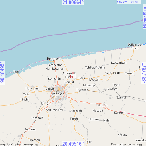
Ixil GPS coordinates[2]
21° 9' 8.46" North, 89° 28' 54.552" West
| Map corner | latitude | longitude |
|---|---|---|
| Upper-left | 21.80664°, | -90.18495° |
| Center: | 21.15235°, | -89.48182° |
| Lower-right: | 20.49516°, | -88.7787° |
| Map W x H: | 145.8×145.8 km | = 90.6×90.6mi |
| max Lat: | 32.7° ⇑21.4% North |
| Ixil: | 21.15235° |
| min Lat: | ⇓78.6% South 14.53588° |
| min Long | Ixil | max Long |
| -117.105° | -89.48182° | -86.73105° |
| W 98.1%⇐ | ⇒1.9% E |
Elevation
Elevation of Ixil is 7 m = 23 ft, and this is 1246.7 m = 4090 ft below average elevation for this country.
| Max E: |
3497 m = 11473 ft | 98.7% |
| Avg. | 1253.7 m = 4113 ft | |
| Ixil | 7 m = 23 ft | |
Min E: |
-1 m = -3 ft | 1.3% |
See also: Mexico elevation on elevation.city.
Geographical zone
Ixil is located in North Torrid zone (between Equator and Tropic of Cancer). Distance of this Northern Tropic circle is 254 km =157.8 mi to North.| Distance of | km | miles | from Ixil |
|---|---|---|---|
| North Pole | 7655.1 | 4756.7 | to North |
| Arctic Circle | 5049.3 | 3137.5 | to North |
| Tropic Cancer | 254 | 157.8 | to North |
| Equator | 2351.9 | 1461.4 | to South |


Nearby cities:
15 places around Ixil: (largest is in red/bold)
• Baca
9.9 km =6.2 mi,  119°
119°
• Chablekal
11.7 km =7.3 mi,  238°
238°
• Chicxulub Pueblo
4 km =2.5 mi, 243°
• Cholul
14.6 km =9.1 mi,  213°
213°
• Conkal
9.6 km =6 mi,  204°
204°
• La Ceiba
16.7 km =10.4 mi,  246°
246°
• Mococha
6 km =3.7 mi,  149°
149°
• Sacapuc
13.1 km =8.1 mi,  83°
83°
• Sitpach
14.6 km =9.1 mi, 196°
• Tamanché
16.6 km =10.3 mi,  264°
264°
• Tekát
6.2 km =3.9 mi,  171°
171°
• Timul
10.5 km =6.5 mi,  64°
64°
• Tixkunchell
11.9 km =7.4 mi,  132°
132°
• Xcunyá
13.8 km =8.6 mi, 260°
• Yaxkukul
12 km =7.5 mi, 147°
Sources, notices
• [Note1] Compared only with cities in Mexico existing in our database
• [Src1] Map data: © OpenStreetMap contributors (CC-BY-SA)
• [Src2] Other city data from geonames.org with taken over terms of usage.
• [Src3] Geographical zone / Annual Mean Temperature by Robert A. Rohde @ Wikipedia
