Chicxulub Puerto geodata
Chicxulub Puerto (Yucatán) is a populated place; located in Mexico in America/Merida (GMT-6) time zone. With population of 6,010 people, there are 1553 cities with bigger population in this country. Compared to other cities in Mexico, 80% of cities are located further ↓South; 98% of cities are located further ←West and 100% of cities have higher elevation than Chicxulub Puerto. Note1


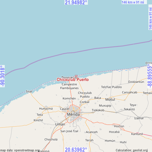
Chicxulub Puerto GPS coordinates[2]
21° 17' 46.248" North, 89° 35' 55.212" West
| Map corner | latitude | longitude |
|---|---|---|
| Upper-left | 21.94982°, | -90.3018° |
| Center: | 21.29618°, | -89.59867° |
| Lower-right: | 20.63962°, | -88.89555° |
| Map W x H: | 145.7×145.7 km | = 90.5×90.5mi |
| max Lat: | 32.7° ⇑20% North |
| Chicxulub Puerto: | 21.29618° |
| min Lat: | ⇓80% South 14.53588° |
| min Long | Chicxulub Puert | max Long |
| -117.105° | -89.59867° | -86.73105° |
| W 98%⇐ | ⇒2% E |
Elevation
Elevation of Chicxulub Puerto is 1 m = 3 ft, and this is 1252.7 m = 4110 ft below average elevation for this country.
| Max E: |
3497 m = 11473 ft | 100% |
| Avg. | 1253.7 m = 4113 ft | |
| Chicxulub Puerto | 1 m = 3 ft | |
Min E: |
-1 m = -3 ft | 0% |
See also: Mexico elevation on elevation.city.
Geographical zone
Chicxulub Puerto is located in North Torrid zone (between Equator and Tropic of Cancer). Distance of this Northern Tropic circle is 238 km =147.9 mi to North.| Distance of | km | miles | from Chicxulub Puerto |
|---|---|---|---|
| North Pole | 7639.1 | 4746.7 | to North |
| Arctic Circle | 5033.3 | 3127.5 | to North |
| Tropic Cancer | 238 | 147.9 | to North |
| Equator | 2367.9 | 1471.3 | to South |


Nearby cities:
15 places around Chicxulub Puerto: (largest is in red/bold)
• Campestre Flamboyanes
11.4 km =7.1 mi,  212°
212°
• Chablekal
22.3 km =13.9 mi,  174°
174°
• Chelem
14.9 km =9.3 mi,  258°
258°
• Chicxulub Pueblo
19.7 km =12.2 mi,  154°
154°
• Chuburná
21.1 km =13.1 mi, 258°
• Ixil
20.1 km =12.5 mi,  142°
142°
• Komchén
22.4 km =13.9 mi,  197°
197°
• La Ceiba
23 km =14.3 mi,  187°
187°
• Progreso
6.6 km =4.1 mi, 257°
• San Ignacio
16.3 km =10.1 mi, 201°
• Sierra Papacal
23.4 km =14.5 mi,  215°
215°
• Tamanché
18 km =11.2 mi, 194°
• Timul
24.4 km =15.2 mi,  118°
118°
• Xcanatún
24.6 km =15.3 mi, 187°
• Xcunyá
18.2 km =11.3 mi,  184°
184°
Sources, notices
• [Note1] Compared only with cities in Mexico existing in our database
• [Src1] Map data: © OpenStreetMap contributors (CC-BY-SA)
• [Src2] Other city data from geonames.org with taken over terms of usage.
• [Src3] Geographical zone / Annual Mean Temperature by Robert A. Rohde @ Wikipedia
