Chicxulub Pueblo geodata
Chicxulub Pueblo (Yucatán) is a seat of a second-order administrative division; located in Mexico in America/Merida (GMT-6) time zone. With population of 4,080 people, there are 2236 cities with bigger population in this country. Compared to other cities in Mexico, 78.4% of cities are located further ↓South; 98.1% of cities are located further ←West and 98.1% of cities have higher elevation than Chicxulub Pueblo. Note1


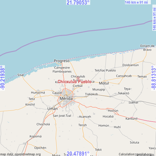
Chicxulub Pueblo GPS coordinates[2]
21° 8' 10.212" North, 89° 30' 58.5" West
| Map corner | latitude | longitude |
|---|---|---|
| Upper-left | 21.79053°, | -90.21938° |
| Center: | 21.13617°, | -89.51625° |
| Lower-right: | 20.47891°, | -88.81313° |
| Map W x H: | 145.8×145.8 km | = 90.6×90.6mi |
| max Lat: | 32.7° ⇑21.6% North |
| Chicxulub Pueblo: | 21.13617° |
| min Lat: | ⇓78.4% South 14.53588° |
| min Long | Chicxulub Puebl | max Long |
| -117.105° | -89.51625° | -86.73105° |
| W 98.1%⇐ | ⇒1.9% E |
Elevation
Elevation of Chicxulub Pueblo is 8 m = 26 ft, and this is 1245.7 m = 4087 ft below average elevation for this country.
| Max E: |
3497 m = 11473 ft | 98.1% |
| Avg. | 1253.7 m = 4113 ft | |
| Chicxulub Pueblo | 8 m = 26 ft | |
Min E: |
-1 m = -3 ft | 1.9% |
See also: Mexico elevation on elevation.city.
Geographical zone
Chicxulub Pueblo is located in North Torrid zone (between Equator and Tropic of Cancer). Distance of this Northern Tropic circle is 255.8 km =158.9 mi to North.| Distance of | km | miles | from Chicxulub Pueblo |
|---|---|---|---|
| North Pole | 7656.9 | 4757.8 | to North |
| Arctic Circle | 5051.1 | 3138.6 | to North |
| Tropic Cancer | 255.8 | 158.9 | to North |
| Equator | 2350.1 | 1460.3 | to South |


Nearby cities:
15 places around Chicxulub Pueblo: (largest is in red/bold)
• Baca
12.6 km =7.8 mi,  104°
104°
• Chablekal
7.8 km =4.8 mi,  235°
235°
• Cholul
11.3 km =7 mi,  202°
202°
• Conkal
7 km =4.3 mi,  183°
183°
• Ixil
4 km =2.5 mi,  63°
63°
• La Ceiba
12.8 km =8 mi,  247°
247°
• Mococha
7.4 km =4.6 mi,  116°
116°
• Sitpach
12.2 km =7.6 mi, 182°
• Tamanché
13 km =8.1 mi,  271°
271°
• Tekát
6.3 km =3.9 mi,  134°
134°
• Timul
14.5 km =9 mi, 64°
• Tixkunchell
13.8 km =8.6 mi, 116°
• Xcanatún
13.6 km =8.5 mi, 240°
• Xcunyá
10 km =6.2 mi, 267°
• Yaxkukul
13 km =8.1 mi, 129°
Sources, notices
• [Note1] Compared only with cities in Mexico existing in our database
• [Src1] Map data: © OpenStreetMap contributors (CC-BY-SA)
• [Src2] Other city data from geonames.org with taken over terms of usage.
• [Src3] Geographical zone / Annual Mean Temperature by Robert A. Rohde @ Wikipedia
