Pocboc geodata
Pocboc (Campeche) is a populated place; located in Mexico in America/Merida (GMT-6) time zone. With population of 1,624 people, there are 5327 cities with bigger population in this country. Compared to other cities in Mexico, 62.2% of cities are located further ↓South; 97.5% of cities are located further ←West and 96.3% of cities have higher elevation than Pocboc. Note1


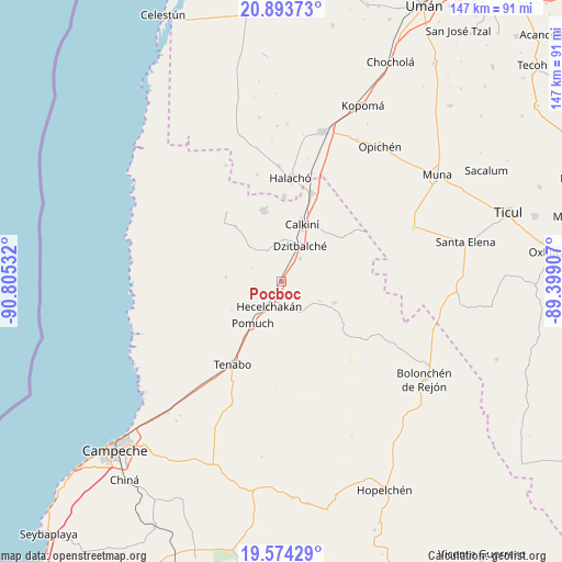
Pocboc GPS coordinates[2]
20° 14' 7.476" North, 90° 6' 7.884" West
| Map corner | latitude | longitude |
|---|---|---|
| Upper-left | 20.89373°, | -90.80532° |
| Center: | 20.23541°, | -90.10219° |
| Lower-right: | 19.57429°, | -89.39907° |
| Map W x H: | 146.7×146.7 km | = 91.2×91.2mi |
| max Lat: | 32.7° ⇑37.8% North |
| Pocboc: | 20.23541° |
| min Lat: | ⇓62.2% South 14.53588° |
| min Long | Pocboc | max Long |
| -117.105° | -90.10219° | -86.73105° |
| W 97.5%⇐ | ⇒2.5% E |
Elevation
Elevation of Pocboc is 11 m = 36 ft, and this is 1242.7 m = 4077 ft below average elevation for this country.
| Max E: |
3497 m = 11473 ft | 96.3% |
| Avg. | 1253.7 m = 4113 ft | |
| Pocboc | 11 m = 36 ft | |
Min E: |
-1 m = -3 ft | 3.7% |
See also: Mexico elevation on elevation.city.
Geographical zone
Pocboc is located in North Torrid zone (between Equator and Tropic of Cancer). Distance of this Northern Tropic circle is 356 km =221.2 mi to North.| Distance of | km | miles | from Pocboc |
|---|---|---|---|
| North Pole | 7757.1 | 4820 | to North |
| Arctic Circle | 5151.2 | 3200.8 | to North |
| Tropic Cancer | 356 | 221.2 | to North |
| Equator | 2250 | 1398.1 | to South |


Nearby cities:
15 places around Pocboc: (largest is in red/bold)
• Bacabchén
7.7 km =4.8 mi,  38°
38°
• Calkiní
15.8 km =9.8 mi,  19°
19°
• Chunkanán
14.6 km =9.1 mi,  273°
273°
• Cuch Holoch
22.1 km =13.7 mi,  1°
1°
• Cumpich
14.8 km =9.2 mi,  111°
111°
• Dzitbalché
10.4 km =6.5 mi,  27°
27°
• Dzitnup
5.7 km =3.5 mi,  185°
185°
• Hecelchakán
7.2 km =4.5 mi,  206°
206°
• Nunkiní
19 km =11.8 mi,  345°
345°
• Pomuch
13.3 km =8.3 mi, 214°
• Pucnachén
18.8 km =11.7 mi,  319°
319°
• San Antonio Sahcabchén
8.8 km =5.5 mi,  334°
334°
• Santa Cruz
3.9 km =2.4 mi,  204°
204°
• Santa Cruz Pueblo
10.9 km =6.8 mi,  359°
359°
• Tepakán
19.1 km =11.9 mi, 19°
Sources, notices
• [Note1] Compared only with cities in Mexico existing in our database
• [Src1] Map data: © OpenStreetMap contributors (CC-BY-SA)
• [Src2] Other city data from geonames.org with taken over terms of usage.
• [Src3] Geographical zone / Annual Mean Temperature by Robert A. Rohde @ Wikipedia
