Cumpich geodata
Cumpich (Campeche) is a populated place; located in Mexico in America/Merida (GMT-6) time zone. With population of 1,587 people, there are 5439 cities with bigger population in this country. Compared to other cities in Mexico, 61.1% of cities are located further ↓South; 97.6% of cities are located further ←West and 84.5% of cities have higher elevation than Cumpich. Note1


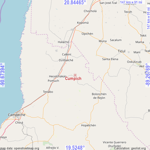
Cumpich GPS coordinates[2]
20° 11' 10.032" North, 89° 58' 14.916" West
| Map corner | latitude | longitude |
|---|---|---|
| Upper-left | 20.84465°, | -90.67394° |
| Center: | 20.18612°, | -89.97081° |
| Lower-right: | 19.5248°, | -89.26769° |
| Map W x H: | 146.8×146.8 km | = 91.2×91.2mi |
| max Lat: | 32.7° ⇑38.9% North |
| Cumpich: | 20.18612° |
| min Lat: | ⇓61.1% South 14.53588° |
| min Long | Cumpich | max Long |
| -117.105° | -89.97081° | -86.73105° |
| W 97.6%⇐ | ⇒2.4% E |
Elevation
Elevation of Cumpich is 48 m = 157 ft, and this is 1205.7 m = 3956 ft below average elevation for this country.
| Max E: |
3497 m = 11473 ft | 84.5% |
| Avg. | 1253.7 m = 4113 ft | |
| Cumpich | 48 m = 157 ft | |
Min E: |
-1 m = -3 ft | 15.5% |
See also: Mexico elevation on elevation.city.
Geographical zone
Cumpich is located in North Torrid zone (between Equator and Tropic of Cancer). Distance of this Northern Tropic circle is 361.4 km =224.6 mi to North.| Distance of | km | miles | from Cumpich |
|---|---|---|---|
| North Pole | 7762.6 | 4823.5 | to North |
| Arctic Circle | 5156.7 | 3204.2 | to North |
| Tropic Cancer | 361.4 | 224.6 | to North |
| Equator | 2244.5 | 1394.7 | to South |


Nearby cities:
15 places around Cumpich: (largest is in red/bold)
• Bacabchén
14.5 km =9 mi,  322°
322°
• Bécal
29 km =18 mi,  348°
348°
• Calkiní
22 km =13.7 mi,  337°
337°
• Chunkanán
29 km =18 mi,  282°
282°
• Dzitbalché
17.2 km =10.7 mi,  328°
328°
• Dzitnup
14.3 km =8.9 mi,  269°
269°
• Hecelchakán
17 km =10.6 mi, 266°
• Nahalal
11.2 km =7 mi,  142°
142°
• Nunkiní
30.2 km =18.8 mi, 322°
• Pocboc
14.8 km =9.2 mi,  291°
291°
• Pomuch
22 km =13.7 mi,  255°
255°
• San Antonio Sahcabchén
22 km =13.7 mi,  307°
307°
• Santa Cruz
15.4 km =9.6 mi, 277°
• Santa Cruz Pueblo
21.5 km =13.4 mi, 319°
• Tepakán
24.6 km =15.3 mi, 342°
Sources, notices
• [Note1] Compared only with cities in Mexico existing in our database
• [Src1] Map data: © OpenStreetMap contributors (CC-BY-SA)
• [Src2] Other city data from geonames.org with taken over terms of usage.
• [Src3] Geographical zone / Annual Mean Temperature by Robert A. Rohde @ Wikipedia
