Hecelchakán geodata
Hecelchakán (Campeche) is a seat of a second-order administrative division; located in Mexico in America/Merida (GMT-6) time zone. With population of 10,285 people, there are 921 cities with bigger population in this country. Compared to other cities in Mexico, 60.9% of cities are located further ↓South; 97.4% of cities are located further ←West and 95.7% of cities have higher elevation than Hecelchakán. Note1


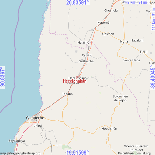
Hecelchakán GPS coordinates[2]
20° 10' 38.46" North, 90° 8' 0.852" West
| Map corner | latitude | longitude |
|---|---|---|
| Upper-left | 20.83591°, | -90.8367° |
| Center: | 20.17735°, | -90.13357° |
| Lower-right: | 19.51599°, | -89.43045° |
| Map W x H: | 146.8×146.8 km | = 91.2×91.2mi |
| max Lat: | 32.7° ⇑39.1% North |
| Hecelchakán: | 20.17735° |
| min Lat: | ⇓60.9% South 14.53588° |
| min Long | Hecelchakán | max Long |
| -117.105° | -90.13357° | -86.73105° |
| W 97.4%⇐ | ⇒2.6% E |
Elevation
Elevation of Hecelchakán is 12 m = 39 ft, and this is 1241.7 m = 4074 ft below average elevation for this country.
| Max E: |
3497 m = 11473 ft | 95.7% |
| Avg. | 1253.7 m = 4113 ft | |
| Hecelchakán | 12 m = 39 ft | |
Min E: |
-1 m = -3 ft | 4.3% |
See also: Mexico elevation on elevation.city.
Geographical zone
Hecelchakán is located in North Torrid zone (between Equator and Tropic of Cancer). Distance of this Northern Tropic circle is 362.4 km =225.2 mi to North.| Distance of | km | miles | from Hecelchakán |
|---|---|---|---|
| North Pole | 7763.6 | 4824.1 | to North |
| Arctic Circle | 5157.7 | 3204.8 | to North |
| Tropic Cancer | 362.4 | 225.2 | to North |
| Equator | 2243.5 | 1394 | to South |


Nearby cities:
15 places around Hecelchakán: (largest is in red/bold)
• Bacabchén
14.8 km =9.2 mi,  33°
33°
• Calkiní
23 km =14.3 mi,  21°
21°
• Chunkanán
13.5 km =8.4 mi,  303°
303°
• Cumpich
17 km =10.6 mi,  86°
86°
• Dzitbalché
17.7 km =11 mi, 27°
• Dzitnup
2.8 km =1.7 mi,  74°
74°
• Nahalal
25.1 km =15.6 mi,  108°
108°
• Nunkiní
24.9 km =15.5 mi,  356°
356°
• Pocboc
7.2 km =4.5 mi, 26°
• Pomuch
6.2 km =3.9 mi,  224°
224°
• Pucnachén
22.6 km =14 mi,  337°
337°
• San Antonio Sahcabchén
14.4 km =8.9 mi, 358°
• Santa Cruz
3.3 km =2.1 mi, 29°
• Santa Cruz Pueblo
17.7 km =11 mi,  10°
10°
• Tenabo
18.1 km =11.2 mi,  212°
212°
Sources, notices
• [Note1] Compared only with cities in Mexico existing in our database
• [Src1] Map data: © OpenStreetMap contributors (CC-BY-SA)
• [Src2] Other city data from geonames.org with taken over terms of usage.
• [Src3] Geographical zone / Annual Mean Temperature by Robert A. Rohde @ Wikipedia
