San Mateo Piñas geodata
San Mateo Piñas (Oaxaca) is a seat of a second-order administrative division; located in Mexico in America/Mexico_City (GMT-6) time zone. With population of 297 people, there are 16869 cities with bigger population in this country. Compared to other cities in Mexico, 97.3% of cities are located further ↑North; 80.7% of cities are located further ←West and 59% of cities have higher elevation than San Mateo Piñas. Note1


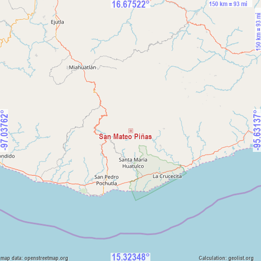
San Mateo Piñas GPS coordinates[2]
16° 0' 1.764" North, 96° 20' 4.164" West
| Map corner | latitude | longitude |
|---|---|---|
| Upper-left | 16.67522°, | -97.03762° |
| Center: | 16.00049°, | -96.33449° |
| Lower-right: | 15.32348°, | -95.63137° |
| Map W x H: | 150.3×150.3 km | = 93.4×93.4mi |
| max Lat: | 32.7° ⇑97.3% North |
| San Mateo Piñas: | 16.00049° |
| min Lat: | ⇓2.7% South 14.53588° |
| min Long | San Mateo Piña | max Long |
| -117.105° | -96.33449° | -86.73105° |
| W 80.7%⇐ | ⇒19.3% E |
Elevation
Elevation of San Mateo Piñas is 1051 m = 3448 ft, and this is 202.7 m = 665 ft below average elevation for this country.
| Max E: |
3497 m = 11473 ft | 59% |
| Avg. | 1253.7 m = 4113 ft | |
| San Mateo Piñas | 1051 m = 3448 ft | |
Min E: |
-1 m = -3 ft | 41% |
See also: Mexico elevation on elevation.city.
Geographical zone
San Mateo Piñas is located in North Torrid zone (between Equator and Tropic of Cancer). Distance of this Northern Tropic circle is 826.8 km =513.7 mi to North.| Distance of | km | miles | from San Mateo Piñas |
|---|---|---|---|
| North Pole | 8228 | 5112.6 | to North |
| Arctic Circle | 5622.1 | 3493.4 | to North |
| Tropic Cancer | 826.8 | 513.7 | to North |
| Equator | 1779.1 | 1105.5 | to South |


Nearby cities:
15 places around San Mateo Piñas: (largest is in red/bold)
• Benito Juárez
13.2 km =8.2 mi,  175°
175°
• Los Naranjos Esquipulas
13.5 km =8.4 mi,  261°
261°
• Paso Ancho
17.6 km =10.9 mi,  173°
173°
• Pluma Hidalgo
12.1 km =7.5 mi,  227°
227°
• San Andrés Lovene
14.7 km =9.1 mi,  72°
72°
• San Francisco Ozolotepec
16.4 km =10.2 mi,  47°
47°
• San Gregorio Ozolotepec
14.6 km =9.1 mi,  2°
2°
• San Juan Ozolotepec
16.8 km =10.4 mi,  28°
28°
• San Marcial Ozolotepec
12.4 km =7.7 mi,  322°
322°
• San Miguel Suchixtepec
17.7 km =11 mi,  305°
305°
• San Pedro el Alto
15.4 km =9.6 mi,  284°
284°
• Santa Cruz Ozolotepec
8.5 km =5.3 mi,  23°
23°
• Santa María Ozolotepec
15.2 km =9.4 mi,  345°
345°
• Santiago Xanica
11.8 km =7.3 mi,  84°
84°
• Santo Domingo Ozolotepec
16.8 km =10.4 mi,  8°
8°
Sources, notices
• [Note1] Compared only with cities in Mexico existing in our database
• [Src1] Map data: © OpenStreetMap contributors (CC-BY-SA)
• [Src2] Other city data from geonames.org with taken over terms of usage.
• [Src3] Geographical zone / Annual Mean Temperature by Robert A. Rohde @ Wikipedia
