Los Plátanos geodata
Los Plátanos (Chiapas) is a populated place; located in Mexico in America/Mexico_City (GMT-6) time zone. With population of 1,992 people, there are 4373 cities with bigger population in this country. Compared to other cities in Mexico, 88.8% of cities are located further ↑North; 90.2% of cities are located further ←West and 55.4% of cities have higher elevation than Los Plátanos. Note1


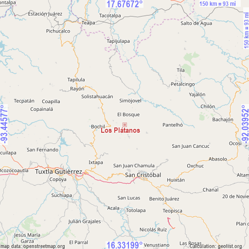
Los Plátanos GPS coordinates[2]
17° 0' 20.016" North, 92° 44' 33.504" West
| Map corner | latitude | longitude |
|---|---|---|
| Upper-left | 17.67672°, | -93.44577° |
| Center: | 17.00556°, | -92.74264° |
| Lower-right: | 16.33199°, | -92.03952° |
| Map W x H: | 149.5×149.5 km | = 92.9×92.9mi |
| max Lat: | 32.7° ⇑88.8% North |
| Los Plátanos: | 17.00556° |
| min Lat: | ⇓11.2% South 14.53588° |
| min Long | Los Plátanos | max Long |
| -117.105° | -92.74264° | -86.73105° |
| W 90.2%⇐ | ⇒9.8% E |
Elevation
Elevation of Los Plátanos is 1183 m = 3881 ft, and this is 70.7 m = 232 ft below average elevation for this country.
| Max E: |
3497 m = 11473 ft | 55.4% |
| Avg. | 1253.7 m = 4113 ft | |
| Los Plátanos | 1183 m = 3881 ft | |
Min E: |
-1 m = -3 ft | 44.6% |
See also: Mexico elevation on elevation.city.
Geographical zone
Los Plátanos is located in North Torrid zone (between Equator and Tropic of Cancer). Distance of this Northern Tropic circle is 715.1 km =444.3 mi to North.| Distance of | km | miles | from Los Plátanos |
|---|---|---|---|
| North Pole | 8116.2 | 5043.2 | to North |
| Arctic Circle | 5510.3 | 3423.9 | to North |
| Tropic Cancer | 715.1 | 444.3 | to North |
| Equator | 1890.8 | 1174.9 | to South |


Nearby cities:
15 places around Los Plátanos: (largest is in red/bold)
• Altagracia
4.5 km =2.8 mi,  311°
311°
• Bayalemo Dos
8.4 km =5.2 mi,  197°
197°
• Carmen Zacatal
10.5 km =6.5 mi,  322°
322°
• Chabajebal
7.7 km =4.8 mi,  53°
53°
• Chuchiltón
10.8 km =6.7 mi,  240°
240°
• El Bosque
6.7 km =4.2 mi,  19°
19°
• El Ámbar
10 km =6.2 mi,  282°
282°
• Jolnachoj
10.7 km =6.6 mi, 199°
• Los Ángeles
4.3 km =2.7 mi,  348°
348°
• Majoval
8.8 km =5.5 mi,  261°
261°
• San Cayetano
5.3 km =3.3 mi, 200°
• San Pedro Nichtalucum
3.6 km =2.2 mi,  27°
27°
• Santiago el Pinar
7.8 km =4.8 mi,  157°
157°
• Yuquín
10.1 km =6.3 mi,  0°
0°
• Álvaro Obregón
7.3 km =4.5 mi,  290°
290°
Sources, notices
• [Note1] Compared only with cities in Mexico existing in our database
• [Src1] Map data: © OpenStreetMap contributors (CC-BY-SA)
• [Src2] Other city data from geonames.org with taken over terms of usage.
• [Src3] Geographical zone / Annual Mean Temperature by Robert A. Rohde @ Wikipedia
