San Cayetano geodata
San Cayetano (Chiapas) is a populated place; located in Mexico in America/Mexico_City (GMT-6) time zone. With population of 1,833 people, there are 4741 cities with bigger population in this country. Compared to other cities in Mexico, 89.5% of cities are located further ↑North; 90.1% of cities are located further ←West and 51.6% of cities have lower elevation than San Cayetano. Note1


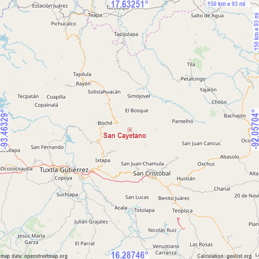
San Cayetano GPS coordinates[2]
16° 57' 40.284" North, 92° 45' 36.576" West
| Map corner | latitude | longitude |
|---|---|---|
| Upper-left | 17.63251°, | -93.46329° |
| Center: | 16.96119°, | -92.76016° |
| Lower-right: | 16.28746°, | -92.05704° |
| Map W x H: | 149.6×149.6 km | = 93×93mi |
| max Lat: | 32.7° ⇑89.5% North |
| San Cayetano: | 16.96119° |
| min Lat: | ⇓10.5% South 14.53588° |
| min Long | San Cayetano | max Long |
| -117.105° | -92.76016° | -86.73105° |
| W 90.1%⇐ | ⇒9.9% E |
Elevation
Elevation of San Cayetano is 1511 m = 4957 ft, and this is 257.3 m = 844 ft above average elevation for this country.
| Max E: |
3497 m = 11473 ft | 48.4% |
| San Cayetano | 1511 m 4957 ft | |
| Avg. | 1253.7 m = 4113 ft | |
Min E: |
-1 m = -3 ft | 51.6% |
See also: Mexico elevation on elevation.city.
Geographical zone
San Cayetano is located in North Torrid zone (between Equator and Tropic of Cancer). Distance of this Northern Tropic circle is 720 km =447.4 mi to North.| Distance of | km | miles | from San Cayetano |
|---|---|---|---|
| North Pole | 8121.2 | 5046.3 | to North |
| Arctic Circle | 5515.3 | 3427 | to North |
| Tropic Cancer | 720 | 447.4 | to North |
| Equator | 1885.9 | 1171.8 | to South |


Nearby cities:
15 places around San Cayetano: (largest is in red/bold)
• Aldama
9.1 km =5.7 mi,  122°
122°
• Altagracia
8.1 km =5 mi,  348°
348°
• Bayalemo Dos
3.1 km =1.9 mi,  193°
193°
• Buenavista
9.7 km =6 mi,  250°
250°
• Chuchiltón
7.5 km =4.7 mi,  267°
267°
• Chuchiltón Anexo Potobtic Dos
9.5 km =5.9 mi,  278°
278°
• Jolnachoj
5.4 km =3.4 mi,  198°
198°
• Los Plátanos
5.3 km =3.3 mi,  20°
20°
• Los Ángeles
9.2 km =5.7 mi,  6°
6°
• Majoval
7.8 km =4.8 mi,  298°
298°
• San Cristobalito
8.3 km =5.2 mi,  229°
229°
• San Pedro Nichtalucum
8.9 km =5.5 mi, 23°
• Santiago el Pinar
5.4 km =3.4 mi, 115°
• Stenlejsotztetic
7.9 km =4.9 mi,  242°
242°
• Álvaro Obregón
9 km =5.6 mi,  326°
326°
Sources, notices
• [Note1] Compared only with cities in Mexico existing in our database
• [Src1] Map data: © OpenStreetMap contributors (CC-BY-SA)
• [Src2] Other city data from geonames.org with taken over terms of usage.
• [Src3] Geographical zone / Annual Mean Temperature by Robert A. Rohde @ Wikipedia
