Chabajebal geodata
Chabajebal (Chiapas) is a populated place; located in Mexico in America/Mexico_City (GMT-6) time zone. With population of 746 people, there are 11739 cities with bigger population in this country. Compared to other cities in Mexico, 88.3% of cities are located further ↑North; 90.6% of cities are located further ←West and 63.2% of cities have higher elevation than Chabajebal. Note1


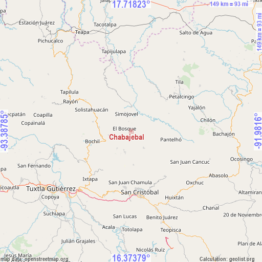
Chabajebal GPS coordinates[2]
17° 2' 49.992" North, 92° 41' 4.992" West
| Map corner | latitude | longitude |
|---|---|---|
| Upper-left | 17.71823°, | -93.38785° |
| Center: | 17.04722°, | -92.68472° |
| Lower-right: | 16.37379°, | -91.9816° |
| Map W x H: | 149.5×149.5 km | = 92.9×92.9mi |
| max Lat: | 32.7° ⇑88.3% North |
| Chabajebal: | 17.04722° |
| min Lat: | ⇓11.7% South 14.53588° |
| min Long | Chabajebal | max Long |
| -117.105° | -92.68472° | -86.73105° |
| W 90.6%⇐ | ⇒9.4% E |
Elevation
Elevation of Chabajebal is 806 m = 2644 ft, and this is 447.7 m = 1469 ft below average elevation for this country.
| Max E: |
3497 m = 11473 ft | 63.2% |
| Avg. | 1253.7 m = 4113 ft | |
| Chabajebal | 806 m = 2644 ft | |
Min E: |
-1 m = -3 ft | 36.8% |
See also: Mexico elevation on elevation.city.
Geographical zone
Chabajebal is located in North Torrid zone (between Equator and Tropic of Cancer). Distance of this Northern Tropic circle is 710.4 km =441.4 mi to North.| Distance of | km | miles | from Chabajebal |
|---|---|---|---|
| North Pole | 8111.6 | 5040.3 | to North |
| Arctic Circle | 5505.7 | 3421.1 | to North |
| Tropic Cancer | 710.4 | 441.4 | to North |
| Equator | 1895.5 | 1177.8 | to South |


Nearby cities:
15 places around Chabajebal: (largest is in red/bold)
• Altagracia
9.7 km =6 mi,  260°
260°
• Chalchihuitán
11.6 km =7.2 mi,  142°
142°
• Chiquinshulum
9.6 km =6 mi,  73°
73°
• Concepción el Amparo
7.3 km =4.5 mi,  62°
62°
• El Bosque
4.3 km =2.7 mi,  293°
293°
• Jolitontic
4.9 km =3 mi,  88°
88°
• Joltealal
7.5 km =4.7 mi, 63°
• Las Limas
5.7 km =3.5 mi,  344°
344°
• Los Plátanos
7.7 km =4.8 mi,  233°
233°
• Los Ángeles
7 km =4.3 mi,  266°
266°
• Natividad Pechuag
9.8 km =6.1 mi,  46°
46°
• Saclum
9.5 km =5.9 mi, 63°
• San Pedro Nichtalucum
4.7 km =2.9 mi,  252°
252°
• Simojovel de Allende
10.8 km =6.7 mi, 343°
• Yuquín
8.2 km =5.1 mi,  312°
312°
Sources, notices
• [Note1] Compared only with cities in Mexico existing in our database
• [Src1] Map data: © OpenStreetMap contributors (CC-BY-SA)
• [Src2] Other city data from geonames.org with taken over terms of usage.
• [Src3] Geographical zone / Annual Mean Temperature by Robert A. Rohde @ Wikipedia
