Majoval geodata
Majoval (Chiapas) is a populated place; located in Mexico in America/Mexico_City (GMT-6) time zone. With population of 754 people, there are 11619 cities with bigger population in this country. Compared to other cities in Mexico, 89% of cities are located further ↑North; 89.7% of cities are located further ←West and 51.7% of cities have lower elevation than Majoval. Note1


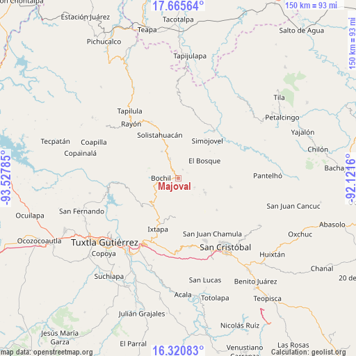
Majoval GPS coordinates[2]
16° 59' 39.984" North, 92° 49' 28.992" West
| Map corner | latitude | longitude |
|---|---|---|
| Upper-left | 17.66564°, | -93.52785° |
| Center: | 16.99444°, | -92.82472° |
| Lower-right: | 16.32083°, | -92.1216° |
| Map W x H: | 149.5×149.5 km | = 92.9×92.9mi |
| max Lat: | 32.7° ⇑89% North |
| Majoval: | 16.99444° |
| min Lat: | ⇓11% South 14.53588° |
| min Long | Majoval | max Long |
| -117.105° | -92.82472° | -86.73105° |
| W 89.7%⇐ | ⇒10.3% E |
Elevation
Elevation of Majoval is 1513 m = 4964 ft, and this is 259.3 m = 851 ft above average elevation for this country.
| Max E: |
3497 m = 11473 ft | 48.3% |
| Majoval | 1513 m 4964 ft | |
| Avg. | 1253.7 m = 4113 ft | |
Min E: |
-1 m = -3 ft | 51.7% |
See also: Mexico elevation on elevation.city.
Geographical zone
Majoval is located in North Torrid zone (between Equator and Tropic of Cancer). Distance of this Northern Tropic circle is 716.3 km =445.1 mi to North.| Distance of | km | miles | from Majoval |
|---|---|---|---|
| North Pole | 8117.5 | 5044 | to North |
| Arctic Circle | 5511.6 | 3424.7 | to North |
| Tropic Cancer | 716.3 | 445.1 | to North |
| Equator | 1889.6 | 1174.1 | to South |


Nearby cities:
15 places around Majoval: (largest is in red/bold)
• Altagracia
6.8 km =4.2 mi,  51°
51°
• Bayalemo Dos
9.1 km =5.7 mi,  137°
137°
• Bochil
7.2 km =4.5 mi,  271°
271°
• Buenavista
7.3 km =4.5 mi,  198°
198°
• Chuchiltón
4.1 km =2.5 mi,  189°
189°
• Chuchiltón Anexo Potobtic Dos
3.5 km =2.2 mi,  227°
227°
• El Ámbar
3.5 km =2.2 mi,  343°
343°
• Jitotol
9 km =5.6 mi,  334°
334°
• Los Plátanos
8.8 km =5.5 mi,  81°
81°
• Monte Grande
7.4 km =4.6 mi,  212°
212°
• San Cayetano
7.8 km =4.8 mi,  118°
118°
• San Cristobalito
9.1 km =5.7 mi,  176°
176°
• Stenlejsotztetic
7.4 km =4.6 mi, 181°
• Yerbabuena Isbontick
8.1 km =5 mi, 212°
• Álvaro Obregón
4.2 km =2.6 mi,  26°
26°
Sources, notices
• [Note1] Compared only with cities in Mexico existing in our database
• [Src1] Map data: © OpenStreetMap contributors (CC-BY-SA)
• [Src2] Other city data from geonames.org with taken over terms of usage.
• [Src3] Geographical zone / Annual Mean Temperature by Robert A. Rohde @ Wikipedia
