San Pedro Nichtalucum geodata
San Pedro Nichtalucum (Chiapas) is a populated place; located in Mexico in America/Mexico_City (GMT-6) time zone. With population of 1,881 people, there are 4622 cities with bigger population in this country. Compared to other cities in Mexico, 88.4% of cities are located further ↑North; 90.3% of cities are located further ←West and 60.8% of cities have higher elevation than San Pedro Nichtalucum. Note1
Current local time in San Pedro Nichtalucum:
08:33 AM, WednesdayDifference from your time zone: hours


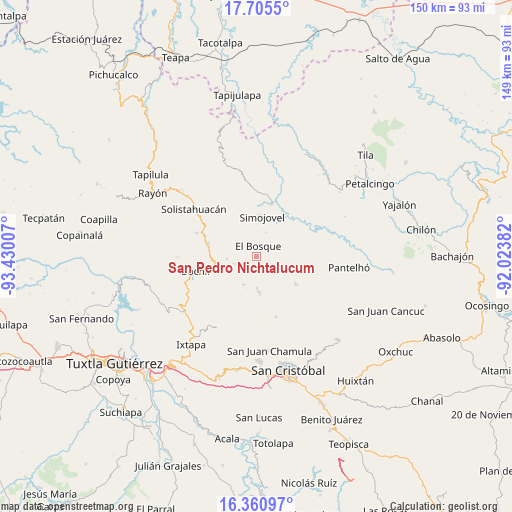
San Pedro Nichtalucum GPS coordinates[2]
17° 2' 3.984" North, 92° 43' 36.984" West
| Map corner | latitude | longitude |
|---|---|---|
| Upper-left | 17.7055°, | -93.43007° |
| Center: | 17.03444°, | -92.72694° |
| Lower-right: | 16.36097°, | -92.02382° |
| Map W x H: | 149.5×149.5 km | = 92.9×92.9mi |
| max Lat: | 32.7° ⇑88.4% North |
| San Pedro Nichtalucum: | 17.03444° |
| min Lat: | ⇓11.6% South 14.53588° |
| min Long | San Pedro Nicht | max Long |
| -117.105° | -92.72694° | -86.73105° |
| W 90.3%⇐ | ⇒9.7% E |
Elevation
Elevation of San Pedro Nichtalucum is 948 m = 3110 ft, and this is 305.7 m = 1003 ft below average elevation for this country.
| Max E: |
3497 m = 11473 ft | 60.8% |
| Avg. | 1253.7 m = 4113 ft | |
| San Pedro Nichtalucum | 948 m = 3110 ft | |
Min E: |
-1 m = -3 ft | 39.2% |
See also: Mexico elevation on elevation.city.
Geographical zone
San Pedro Nichtalucum is located in North Torrid zone (between Equator and Tropic of Cancer). Distance of this Northern Tropic circle is 711.9 km =442.4 mi to North.| Distance of | km | miles | from San Pedro Nichtalucum |
|---|---|---|---|
| North Pole | 8113 | 5041.2 | to North |
| Arctic Circle | 5507.1 | 3422 | to North |
| Tropic Cancer | 711.9 | 442.4 | to North |
| Equator | 1894.1 | 1176.9 | to South |


Nearby cities:
15 places around San Pedro Nichtalucum: (largest is in red/bold)
• Altagracia
5.1 km =3.2 mi,  267°
267°
• Carmen Zacatal
9.5 km =5.9 mi,  302°
302°
• Chabajebal
4.7 km =2.9 mi,  72°
72°
• Cálido
9.6 km =6 mi,  318°
318°
• El Bosque
3.2 km =2 mi,  10°
10°
• El Ámbar
11.4 km =7.1 mi,  264°
264°
• Jolitontic
9.5 km =5.9 mi,  80°
80°
• Las Limas
7.6 km =4.7 mi,  23°
23°
• Los Plátanos
3.6 km =2.2 mi,  207°
207°
• Los Ángeles
2.7 km =1.7 mi,  292°
292°
• Majoval
11.3 km =7 mi,  246°
246°
• San Cayetano
8.9 km =5.5 mi,  203°
203°
• Santiago el Pinar
10.5 km =6.5 mi,  172°
172°
• Yuquín
7.1 km =4.4 mi,  346°
346°
• Álvaro Obregón
8.6 km =5.3 mi, 265°
Sources, notices
• [Note1] Compared only with cities in Mexico existing in our database
• [Src1] Map data: © OpenStreetMap contributors (CC-BY-SA)
• [Src2] Other city data from geonames.org with taken over terms of usage.
• [Src3] Geographical zone / Annual Mean Temperature by Robert A. Rohde @ Wikipedia
