Mier y Noriega geodata
Mier y Noriega (Nuevo León) is a seat of a second-order administrative division; located in Mexico in America/Monterrey (GMT-6) time zone. With population of 1,214 people, there are 7165 cities with bigger population in this country. Compared to other cities in Mexico, 88.9% of cities are located further ↓South; 65.4% of cities are located further →East and 57.5% of cities have lower elevation than Mier y Noriega. Note1


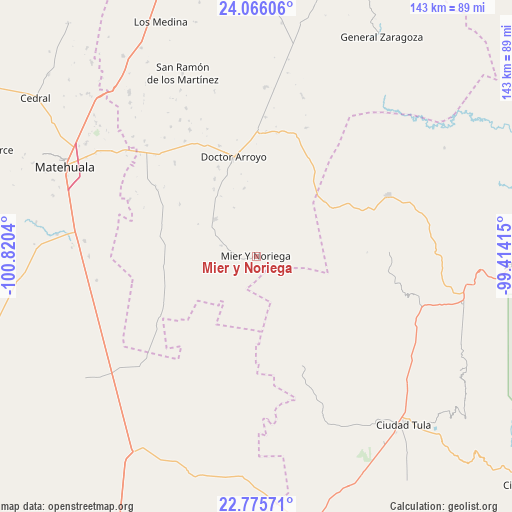
Mier y Noriega GPS coordinates[2]
23° 25' 20.856" North, 100° 7' 2.172" West
| Map corner | latitude | longitude |
|---|---|---|
| Upper-left | 24.06606°, | -100.8204° |
| Center: | 23.42246°, | -100.11727° |
| Lower-right: | 22.77571°, | -99.41415° |
| Map W x H: | 143.5×143.5 km | = 89.2×89.2mi |
| max Lat: | 32.7° ⇑11.1% North |
| Mier y Noriega: | 23.42246° |
| min Lat: | ⇓88.9% South 14.53588° |
| min Long | Mier y Noriega | max Long |
| -117.105° | -100.11727° | -86.73105° |
| W 34.6%⇐ | ⇒65.4% E |
Elevation
Elevation of Mier y Noriega is 1678 m = 5505 ft, and this is 424.3 m = 1392 ft above average elevation for this country.
| Max E: |
3497 m = 11473 ft | 42.5% |
| Mier y Noriega | 1678 m 5505 ft | |
| Avg. | 1253.7 m = 4113 ft | |
Min E: |
-1 m = -3 ft | 57.5% |
See also: Mexico elevation on elevation.city.
Geographical zone
Mier y Noriega is located in North Torrid zone (between Equator and Tropic of Cancer). Distance of this Northern Tropic circle is 1.6 km =1 mi to North.| Distance of | km | miles | from Mier y Noriega |
|---|---|---|---|
| North Pole | 7402.7 | 4599.8 | to North |
| Arctic Circle | 4796.8 | 2980.6 | to North |
| Tropic Cancer | 1.6 | 1 | to North |
| Equator | 2604.3 | 1618.2 | to South |


Nearby cities:
15 places around Mier y Noriega: (largest is in red/bold)
• Bustamante
36.6 km =22.7 mi,  87°
87°
• Calabacillas
45.2 km =28.1 mi,  120°
120°
• Cerros Blancos
11.9 km =7.4 mi,  217°
217°
• Doctor Arroyo
28.5 km =17.7 mi,  346°
346°
• El Aguacate
37.4 km =23.2 mi,  105°
105°
• Felipe Ángeles
37.1 km =23.1 mi,  95°
95°
• La Cardona
14.1 km =8.8 mi, 98°
• La Moreña
21.7 km =13.5 mi,  253°
253°
• La Peña
46.2 km =28.7 mi,  70°
70°
• Las Palomas (Lajillas)
15.2 km =9.4 mi,  334°
334°
• Miquihuana
40.7 km =25.3 mi, 65°
• Salitrillo
41.2 km =25.6 mi,  134°
134°
• San Ignacio
26.5 km =16.5 mi,  193°
193°
• San José del Llano
22.4 km =13.9 mi,  56°
56°
• San Rafael
46.8 km =29.1 mi,  135°
135°
Sources, notices
• [Note1] Compared only with cities in Mexico existing in our database
• [Src1] Map data: © OpenStreetMap contributors (CC-BY-SA)
• [Src2] Other city data from geonames.org with taken over terms of usage.
• [Src3] Geographical zone / Annual Mean Temperature by Robert A. Rohde @ Wikipedia
