Kopoma geodata
Kopoma (Yucatán) is a populated place; located in Mexico in America/Merida (GMT-6) time zone. With population of 2,026 people, there are 4294 cities with bigger population in this country. Compared to other cities in Mexico, 70.9% of cities are located further ↓South; 97.6% of cities are located further ←West and 95.7% of cities have higher elevation than Kopoma. Note1


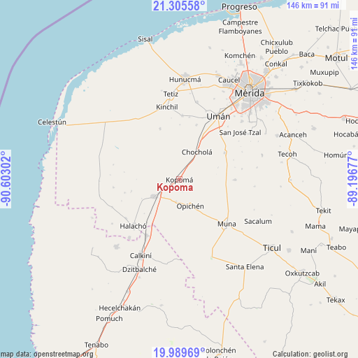
Kopoma GPS coordinates[2]
20° 38' 56.616" North, 89° 53' 59.604" West
| Map corner | latitude | longitude |
|---|---|---|
| Upper-left | 21.30558°, | -90.60302° |
| Center: | 20.64906°, | -89.89989° |
| Lower-right: | 19.98969°, | -89.19677° |
| Map W x H: | 146.3×146.3 km | = 90.9×90.9mi |
| max Lat: | 32.7° ⇑29.1% North |
| Kopoma: | 20.64906° |
| min Lat: | ⇓70.9% South 14.53588° |
| min Long | Kopoma | max Long |
| -117.105° | -89.89989° | -86.73105° |
| W 97.6%⇐ | ⇒2.4% E |
Elevation
Elevation of Kopoma is 12 m = 39 ft, and this is 1241.7 m = 4074 ft below average elevation for this country.
| Max E: |
3497 m = 11473 ft | 95.7% |
| Avg. | 1253.7 m = 4113 ft | |
| Kopoma | 12 m = 39 ft | |
Min E: |
-1 m = -3 ft | 4.3% |
See also: Mexico elevation on elevation.city.
Geographical zone
Kopoma is located in North Torrid zone (between Equator and Tropic of Cancer). Distance of this Northern Tropic circle is 310 km =192.6 mi to North.| Distance of | km | miles | from Kopoma |
|---|---|---|---|
| North Pole | 7711.1 | 4791.5 | to North |
| Arctic Circle | 5105.2 | 3172.2 | to North |
| Tropic Cancer | 310 | 192.6 | to North |
| Equator | 2296 | 1426.7 | to South |


Nearby cities:
15 places around Kopoma: (largest is in red/bold)
• Abala
22.8 km =14.2 mi,  90°
90°
• Bolón
23.4 km =14.5 mi,  17°
17°
• Calcehtoc
9.1 km =5.7 mi,  188°
188°
• Chochola
13.4 km =8.3 mi,  32°
32°
• Dzidzibachi
25.2 km =15.7 mi,  249°
249°
• Kuchel
22.4 km =13.9 mi,  0°
0°
• Maxcanú
12.7 km =7.9 mi,  235°
235°
• Opichen
11.7 km =7.3 mi,  157°
157°
• Paraíso
22.8 km =14.2 mi,  277°
277°
• Poxila
21.3 km =13.2 mi, 27°
• San Antonio Tedzidz
22.2 km =13.8 mi,  339°
339°
• Santa Rosa
20.2 km =12.6 mi,  256°
256°
• Santo Domingo
23.2 km =14.4 mi, 256°
• Xtepen
25.2 km =15.7 mi,  40°
40°
• Yaxcopoil
21.3 km =13.2 mi,  60°
60°
Sources, notices
• [Note1] Compared only with cities in Mexico existing in our database
• [Src1] Map data: © OpenStreetMap contributors (CC-BY-SA)
• [Src2] Other city data from geonames.org with taken over terms of usage.
• [Src3] Geographical zone / Annual Mean Temperature by Robert A. Rohde @ Wikipedia
