Pachiquita geodata
Pachiquita (Hidalgo) is a populated place; located in Mexico in America/Mexico_City (GMT-6) time zone. With population of 1,158 people, there are 7487 cities with bigger population in this country. Compared to other cities in Mexico, 74% of cities are located further ↓South; 59.5% of cities are located further ←West and 64.9% of cities have higher elevation than Pachiquita. Note1


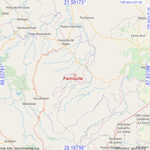
Pachiquita GPS coordinates[2]
20° 50' 45.888" North, 98° 20' 5.208" West
| Map corner | latitude | longitude |
|---|---|---|
| Upper-left | 21.50173°, | -99.03791° |
| Center: | 20.84608°, | -98.33478° |
| Lower-right: | 20.18756°, | -97.63166° |
| Map W x H: | 146.1×146.1 km | = 90.8×90.8mi |
| max Lat: | 32.7° ⇑26% North |
| Pachiquita: | 20.84608° |
| min Lat: | ⇓74% South 14.53588° |
| min Long | Pachiquita | max Long |
| -117.105° | -98.33478° | -86.73105° |
| W 59.5%⇐ | ⇒40.5% E |
Elevation
Elevation of Pachiquita is 692 m = 2270 ft, and this is 561.7 m = 1843 ft below average elevation for this country.
| Max E: |
3497 m = 11473 ft | 64.9% |
| Avg. | 1253.7 m = 4113 ft | |
| Pachiquita | 692 m = 2270 ft | |
Min E: |
-1 m = -3 ft | 35.1% |
See also: Mexico elevation on elevation.city.
Geographical zone
Pachiquita is located in North Torrid zone (between Equator and Tropic of Cancer). Distance of this Northern Tropic circle is 288.1 km =179 mi to North.| Distance of | km | miles | from Pachiquita |
|---|---|---|---|
| North Pole | 7689.2 | 4777.8 | to North |
| Arctic Circle | 5083.3 | 3158.6 | to North |
| Tropic Cancer | 288.1 | 179 | to North |
| Equator | 2317.9 | 1440.3 | to South |


Nearby cities:
15 places around Pachiquita: (largest is in red/bold)
• Atlalco
5.9 km =3.7 mi,  121°
121°
• Chiapa
4.9 km =3 mi,  35°
35°
• Chiatitla
6.7 km =4.2 mi,  1°
1°
• Huitztipan
3.1 km =1.9 mi,  250°
250°
• Nanayatla
7.9 km =4.9 mi,  107°
107°
• Pocantla
2.3 km =1.4 mi,  96°
96°
• Pohuantitla
3.5 km =2.2 mi, 43°
• San Gregorio
6.5 km =4 mi,  243°
243°
• Santa Teresa
7 km =4.3 mi,  314°
314°
• Tenamaxtepec
5 km =3.1 mi,  326°
326°
• Tlaltecatla
5.6 km =3.5 mi,  68°
68°
• Tlatlazoquico
3.6 km =2.2 mi,  218°
218°
• Xochiatipan de Castillo
5.3 km =3.3 mi, 103°
• Xococapa
4.4 km =2.7 mi,  202°
202°
• Xocotitla
5.4 km =3.4 mi,  132°
132°
Sources, notices
• [Note1] Compared only with cities in Mexico existing in our database
• [Src1] Map data: © OpenStreetMap contributors (CC-BY-SA)
• [Src2] Other city data from geonames.org with taken over terms of usage.
• [Src3] Geographical zone / Annual Mean Temperature by Robert A. Rohde @ Wikipedia
