Huitztipan geodata
Huitztipan (Veracruz) is a populated place; located in Mexico in America/Mexico_City (GMT-6) time zone. With population of 892 people, there are 9779 cities with bigger population in this country. Compared to other cities in Mexico, 73.8% of cities are located further ↓South; 59.1% of cities are located further ←West and 69.6% of cities have higher elevation than Huitztipan. Note1


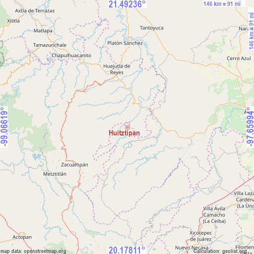
Huitztipan GPS coordinates[2]
20° 50' 12.012" North, 98° 21' 47.016" West
| Map corner | latitude | longitude |
|---|---|---|
| Upper-left | 21.49236°, | -99.06619° |
| Center: | 20.83667°, | -98.36306° |
| Lower-right: | 20.17811°, | -97.65994° |
| Map W x H: | 146.1×146.1 km | = 90.8×90.8mi |
| max Lat: | 32.7° ⇑26.2% North |
| Huitztipan: | 20.83667° |
| min Lat: | ⇓73.8% South 14.53588° |
| min Long | Huitztipan | max Long |
| -117.105° | -98.36306° | -86.73105° |
| W 59.1%⇐ | ⇒40.9% E |
Elevation
Elevation of Huitztipan is 435 m = 1427 ft, and this is 818.7 m = 2686 ft below average elevation for this country.
| Max E: |
3497 m = 11473 ft | 69.6% |
| Avg. | 1253.7 m = 4113 ft | |
| Huitztipan | 435 m = 1427 ft | |
Min E: |
-1 m = -3 ft | 30.4% |
See also: Mexico elevation on elevation.city.
Geographical zone
Huitztipan is located in North Torrid zone (between Equator and Tropic of Cancer). Distance of this Northern Tropic circle is 289.1 km =179.6 mi to North.| Distance of | km | miles | from Huitztipan |
|---|---|---|---|
| North Pole | 7690.2 | 4778.5 | to North |
| Arctic Circle | 5084.4 | 3159.3 | to North |
| Tropic Cancer | 289.1 | 179.6 | to North |
| Equator | 2316.8 | 1439.6 | to South |


Nearby cities:
15 places around Huitztipan: (largest is in red/bold)
• Aguacatitla
7.3 km =4.5 mi,  292°
292°
• Arnatepec
6.8 km =4.2 mi,  223°
223°
• Chahuatlán
6.7 km =4.2 mi,  207°
207°
• Chiapa
7.6 km =4.7 mi,  48°
48°
• Coacoaco
7.7 km =4.8 mi,  262°
262°
• Pachiquita
3.1 km =1.9 mi,  70°
70°
• Pocantla
5.3 km =3.3 mi,  81°
81°
• Pohuantitla
6.4 km =4 mi,  56°
56°
• San Gregorio
3.4 km =2.1 mi,  237°
237°
• Santa Cruz
7.4 km =4.6 mi,  232°
232°
• Santa Teresa
6.3 km =3.9 mi,  340°
340°
• Tenamaxtepec
5.2 km =3.2 mi,  1°
1°
• Tlatlazoquico
1.9 km =1.2 mi,  158°
158°
• Xococapa
3.3 km =2.1 mi, 158°
• Xocotitla
7.4 km =4.6 mi,  110°
110°
Sources, notices
• [Note1] Compared only with cities in Mexico existing in our database
• [Src1] Map data: © OpenStreetMap contributors (CC-BY-SA)
• [Src2] Other city data from geonames.org with taken over terms of usage.
• [Src3] Geographical zone / Annual Mean Temperature by Robert A. Rohde @ Wikipedia
