Pocantla geodata
Pocantla (Veracruz) is a populated place; located in Mexico in America/Mexico_City (GMT-6) time zone. With population of 659 people, there are 13168 cities with bigger population in this country. Compared to other cities in Mexico, 73.9% of cities are located further ↓South; 59.7% of cities are located further ←West and 69.4% of cities have higher elevation than Pocantla. Note1


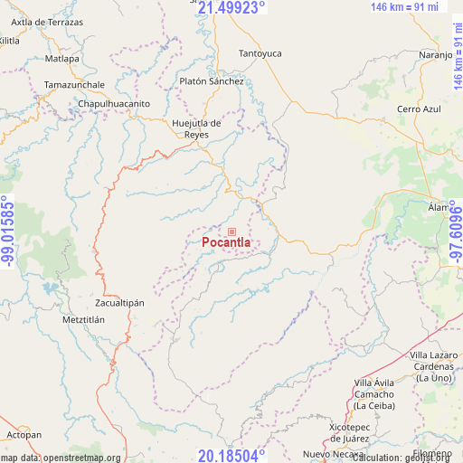
Pocantla GPS coordinates[2]
20° 50' 36.852" North, 98° 18' 45.792" West
| Map corner | latitude | longitude |
|---|---|---|
| Upper-left | 21.49923°, | -99.01585° |
| Center: | 20.84357°, | -98.31272° |
| Lower-right: | 20.18504°, | -97.6096° |
| Map W x H: | 146.1×146.1 km | = 90.8×90.8mi |
| max Lat: | 32.7° ⇑26.1% North |
| Pocantla: | 20.84357° |
| min Lat: | ⇓73.9% South 14.53588° |
| min Long | Pocantla | max Long |
| -117.105° | -98.31272° | -86.73105° |
| W 59.7%⇐ | ⇒40.3% E |
Elevation
Elevation of Pocantla is 444 m = 1457 ft, and this is 809.7 m = 2656 ft below average elevation for this country.
| Max E: |
3497 m = 11473 ft | 69.4% |
| Avg. | 1253.7 m = 4113 ft | |
| Pocantla | 444 m = 1457 ft | |
Min E: |
-1 m = -3 ft | 30.6% |
See also: Mexico elevation on elevation.city.
Geographical zone
Pocantla is located in North Torrid zone (between Equator and Tropic of Cancer). Distance of this Northern Tropic circle is 288.3 km =179.1 mi to North.| Distance of | km | miles | from Pocantla |
|---|---|---|---|
| North Pole | 7689.5 | 4778 | to North |
| Arctic Circle | 5083.6 | 3158.8 | to North |
| Tropic Cancer | 288.3 | 179.1 | to North |
| Equator | 2317.6 | 1440.1 | to South |


Nearby cities:
15 places around Pocantla: (largest is in red/bold)
• Acanoa
6.8 km =4.2 mi,  138°
138°
• Atlalco
3.9 km =2.4 mi,  134°
134°
• Chiapa
4.3 km =2.7 mi,  6°
6°
• Chiatitla
7.2 km =4.5 mi,  343°
343°
• Huitztipan
5.3 km =3.3 mi,  261°
261°
• Nanayatla
5.7 km =3.5 mi,  112°
112°
• Ohuatipa
7.6 km =4.7 mi,  43°
43°
• Pachiquita
2.3 km =1.4 mi,  276°
276°
• Pohuantitla
2.8 km =1.7 mi,  2°
2°
• Tenamaxtepec
6.7 km =4.2 mi,  311°
311°
• Tlaltecatla
3.7 km =2.3 mi,  51°
51°
• Tlatlazoquico
5.2 km =3.2 mi,  240°
240°
• Xochiatipan de Castillo
3 km =1.9 mi, 108°
• Xococapa
5.5 km =3.4 mi,  226°
226°
• Xocotitla
3.8 km =2.4 mi,  153°
153°
Sources, notices
• [Note1] Compared only with cities in Mexico existing in our database
• [Src1] Map data: © OpenStreetMap contributors (CC-BY-SA)
• [Src2] Other city data from geonames.org with taken over terms of usage.
• [Src3] Geographical zone / Annual Mean Temperature by Robert A. Rohde @ Wikipedia
