San Gregorio geodata
San Gregorio (Hidalgo) is a populated place; located in Mexico in America/Mexico_City (GMT-6) time zone. With population of 964 people, there are 9028 cities with bigger population in this country. Compared to other cities in Mexico, 73.6% of cities are located further ↓South; 58.7% of cities are located further ←West and 67.9% of cities have higher elevation than San Gregorio. Note1


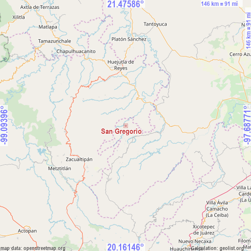
San Gregorio GPS coordinates[2]
20° 49' 12.324" North, 98° 23' 26.988" West
| Map corner | latitude | longitude |
|---|---|---|
| Upper-left | 21.47586°, | -99.09396° |
| Center: | 20.82009°, | -98.39083° |
| Lower-right: | 20.16146°, | -97.68771° |
| Map W x H: | 146.1×146.1 km | = 90.8×90.8mi |
| max Lat: | 32.7° ⇑26.4% North |
| San Gregorio: | 20.82009° |
| min Lat: | ⇓73.6% South 14.53588° |
| min Long | San Gregorio | max Long |
| -117.105° | -98.39083° | -86.73105° |
| W 58.7%⇐ | ⇒41.3% E |
Elevation
Elevation of San Gregorio is 533 m = 1749 ft, and this is 720.7 m = 2365 ft below average elevation for this country.
| Max E: |
3497 m = 11473 ft | 67.9% |
| Avg. | 1253.7 m = 4113 ft | |
| San Gregorio | 533 m = 1749 ft | |
Min E: |
-1 m = -3 ft | 32.1% |
See also: Mexico elevation on elevation.city.
Geographical zone
San Gregorio is located in North Torrid zone (between Equator and Tropic of Cancer). Distance of this Northern Tropic circle is 290.9 km =180.8 mi to North.| Distance of | km | miles | from San Gregorio |
|---|---|---|---|
| North Pole | 7692.1 | 4779.6 | to North |
| Arctic Circle | 5086.2 | 3160.4 | to North |
| Tropic Cancer | 290.9 | 180.8 | to North |
| Equator | 2315 | 1438.5 | to South |


Nearby cities:
15 places around San Gregorio: (largest is in red/bold)
• Aguacatitla
6 km =3.7 mi,  319°
319°
• Arnatepec
3.6 km =2.2 mi,  210°
210°
• Atempa
7.7 km =4.8 mi,  199°
199°
• Chahuatlán
4.1 km =2.5 mi,  183°
183°
• Coacoaco
4.9 km =3 mi,  279°
279°
• Huitztipan
3.4 km =2.1 mi,  57°
57°
• Ilamatlán
7 km =4.3 mi,  231°
231°
• Pachiquita
6.5 km =4 mi, 63°
• Santa Cruz
4 km =2.5 mi, 228°
• Santa Teresa
7.8 km =4.8 mi,  5°
5°
• Tenamaxtepec
7.7 km =4.8 mi,  23°
23°
• Tlatlazoquico
3.6 km =2.2 mi,  88°
88°
• Xococapa
4.3 km =2.7 mi,  106°
106°
• Xoxolpa
7.1 km =4.4 mi,  330°
330°
• Zontecomatlán de López y Fuentes
8.1 km =5 mi,  142°
142°
Sources, notices
• [Note1] Compared only with cities in Mexico existing in our database
• [Src1] Map data: © OpenStreetMap contributors (CC-BY-SA)
• [Src2] Other city data from geonames.org with taken over terms of usage.
• [Src3] Geographical zone / Annual Mean Temperature by Robert A. Rohde @ Wikipedia
