Lomas de Miradores geodata
Lomas de Miradores (Veracruz) is a populated place; located in Mexico in America/Mexico_City (GMT-6) time zone. With population of 991 people, there are 8788 cities with bigger population in this country. Compared to other cities in Mexico, 54.9% of cities are located further ↑North; 77.4% of cities are located further ←West and 61% of cities have higher elevation than Lomas de Miradores. Note1


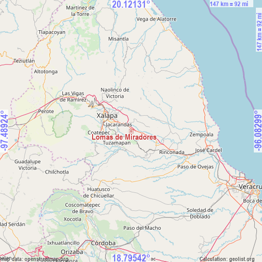
Lomas de Miradores GPS coordinates[2]
19° 27' 34.992" North, 96° 47' 9.996" West
| Map corner | latitude | longitude |
|---|---|---|
| Upper-left | 20.12131°, | -97.48924° |
| Center: | 19.45972°, | -96.78611° |
| Lower-right: | 18.79542°, | -96.08299° |
| Map W x H: | 147.4×147.4 km | = 91.6×91.6mi |
| max Lat: | 32.7° ⇑54.9% North |
| Lomas de Miradores: | 19.45972° |
| min Lat: | ⇓45.1% South 14.53588° |
| min Long | Lomas de Mirado | max Long |
| -117.105° | -96.78611° | -86.73105° |
| W 77.4%⇐ | ⇒22.6% E |
Elevation
Elevation of Lomas de Miradores is 939 m = 3081 ft, and this is 314.7 m = 1032 ft below average elevation for this country.
| Max E: |
3497 m = 11473 ft | 61% |
| Avg. | 1253.7 m = 4113 ft | |
| Lomas de Miradores | 939 m = 3081 ft | |
Min E: |
-1 m = -3 ft | 39% |
See also: Mexico elevation on elevation.city.
Geographical zone
Lomas de Miradores is located in North Torrid zone (between Equator and Tropic of Cancer). Distance of this Northern Tropic circle is 442.2 km =274.8 mi to North.| Distance of | km | miles | from Lomas de Miradores |
|---|---|---|---|
| North Pole | 7843.3 | 4873.6 | to North |
| Arctic Circle | 5237.5 | 3254.4 | to North |
| Tropic Cancer | 442.2 | 274.8 | to North |
| Equator | 2163.7 | 1344.5 | to South |


Nearby cities:
15 places around Lomas de Miradores: (largest is in red/bold)
• Alborada
9 km =5.6 mi,  262°
262°
• Bella Esperanza
8.9 km =5.5 mi,  250°
250°
• Cerro Gordo
9.5 km =5.9 mi,  108°
108°
• Chavarrillo
3.9 km =2.4 mi,  193°
193°
• Dos Ríos
3.1 km =1.9 mi,  332°
332°
• El Chico
5.3 km =3.3 mi,  277°
277°
• El Lencero
4.5 km =2.8 mi,  315°
315°
• El Roble
7.6 km =4.7 mi,  134°
134°
• El Terrero
8.7 km =5.4 mi,  351°
351°
• Estación Chavarrillo
4.3 km =2.7 mi,  214°
214°
• Estanzuela
7.6 km =4.7 mi,  270°
270°
• Jacarandas
8 km =5 mi,  299°
299°
• La Tinaja
7 km =4.3 mi,  26°
26°
• Pinoltepec
3.8 km =2.4 mi,  121°
121°
• Rancho Viejo
1.8 km =1.1 mi,  164°
164°
Sources, notices
• [Note1] Compared only with cities in Mexico existing in our database
• [Src1] Map data: © OpenStreetMap contributors (CC-BY-SA)
• [Src2] Other city data from geonames.org with taken over terms of usage.
• [Src3] Geographical zone / Annual Mean Temperature by Robert A. Rohde @ Wikipedia
