La Tinaja geodata
La Tinaja (Veracruz) is a populated place; located in Mexico in America/Mexico_City (GMT-6) time zone. With population of 968 people, there are 8990 cities with bigger population in this country. Compared to other cities in Mexico, 53.7% of cities are located further ↑North; 77.8% of cities are located further ←West and 61.5% of cities have higher elevation than La Tinaja. Note1


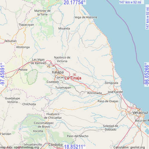
La Tinaja GPS coordinates[2]
19° 30' 58.248" North, 96° 45' 20.808" West
| Map corner | latitude | longitude |
|---|---|---|
| Upper-left | 20.17754°, | -97.45891° |
| Center: | 19.51618°, | -96.75578° |
| Lower-right: | 18.85211°, | -96.05266° |
| Map W x H: | 147.4×147.4 km | = 91.6×91.6mi |
| max Lat: | 32.7° ⇑53.7% North |
| La Tinaja: | 19.51618° |
| min Lat: | ⇓46.3% South 14.53588° |
| min Long | La Tinaja | max Long |
| -117.105° | -96.75578° | -86.73105° |
| W 77.8%⇐ | ⇒22.2% E |
Elevation
Elevation of La Tinaja is 908 m = 2979 ft, and this is 345.7 m = 1134 ft below average elevation for this country.
| Max E: |
3497 m = 11473 ft | 61.5% |
| Avg. | 1253.7 m = 4113 ft | |
| La Tinaja | 908 m = 2979 ft | |
Min E: |
-1 m = -3 ft | 38.5% |
See also: Mexico elevation on elevation.city.
Geographical zone
La Tinaja is located in North Torrid zone (between Equator and Tropic of Cancer). Distance of this Northern Tropic circle is 435.9 km =270.9 mi to North.| Distance of | km | miles | from La Tinaja |
|---|---|---|---|
| North Pole | 7837.1 | 4869.7 | to North |
| Arctic Circle | 5231.2 | 3250.5 | to North |
| Tropic Cancer | 435.9 | 270.9 | to North |
| Equator | 2170 | 1348.4 | to South |


Nearby cities:
15 places around La Tinaja: (largest is in red/bold)
• Almolonga
8.7 km =5.4 mi,  340°
340°
• Blanca Espuma
10.1 km =6.3 mi,  44°
44°
• Chicuasen
8.9 km =5.5 mi,  81°
81°
• Dos Ríos
5.8 km =3.6 mi,  232°
232°
• El Lencero
7 km =4.3 mi,  244°
244°
• El Terrero
5.1 km =3.2 mi,  297°
297°
• Lomas de Miradores
7 km =4.3 mi,  206°
206°
• Mesa de Guadalupe
7.9 km =4.9 mi,  47°
47°
• Otates
4.2 km =2.6 mi, 82°
• Pinoltepec
8.3 km =5.2 mi,  179°
179°
• Rancho Viejo
8.4 km =5.2 mi,  198°
198°
• San Nicolás
4.6 km =2.9 mi, 342°
• Seis de Enero
9.9 km =6.2 mi,  305°
305°
• Trapiche del Rosario
3.4 km =2.1 mi,  27°
27°
• Villa Nueva
9.7 km =6 mi,  90°
90°
Sources, notices
• [Note1] Compared only with cities in Mexico existing in our database
• [Src1] Map data: © OpenStreetMap contributors (CC-BY-SA)
• [Src2] Other city data from geonames.org with taken over terms of usage.
• [Src3] Geographical zone / Annual Mean Temperature by Robert A. Rohde @ Wikipedia
