San Nicolás geodata
San Nicolás (Veracruz) is a populated place; located in Mexico in America/Mexico_City (GMT-6) time zone. With population of 698 people, there are 12480 cities with bigger population in this country. Compared to other cities in Mexico, 53% of cities are located further ↑North; 77.7% of cities are located further ←West and 66.9% of cities have higher elevation than San Nicolás. Note1


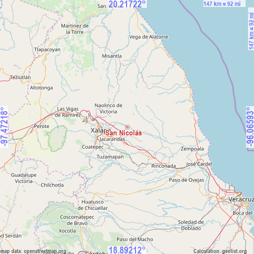
San Nicolás GPS coordinates[2]
19° 33' 21.708" North, 96° 46' 8.58" West
| Map corner | latitude | longitude |
|---|---|---|
| Upper-left | 20.21722°, | -97.47218° |
| Center: | 19.55603°, | -96.76905° |
| Lower-right: | 18.89212°, | -96.06593° |
| Map W x H: | 147.3×147.3 km | = 91.5×91.5mi |
| max Lat: | 32.7° ⇑53% North |
| San Nicolás: | 19.55603° |
| min Lat: | ⇓47% South 14.53588° |
| min Long | San Nicolás | max Long |
| -117.105° | -96.76905° | -86.73105° |
| W 77.7%⇐ | ⇒22.3% E |
Elevation
Elevation of San Nicolás is 588 m = 1929 ft, and this is 665.7 m = 2184 ft below average elevation for this country.
| Max E: |
3497 m = 11473 ft | 66.9% |
| Avg. | 1253.7 m = 4113 ft | |
| San Nicolás | 588 m = 1929 ft | |
Min E: |
-1 m = -3 ft | 33.1% |
See also: Mexico elevation on elevation.city.
Geographical zone
San Nicolás is located in North Torrid zone (between Equator and Tropic of Cancer). Distance of this Northern Tropic circle is 431.5 km =268.1 mi to North.| Distance of | km | miles | from San Nicolás |
|---|---|---|---|
| North Pole | 7832.6 | 4867 | to North |
| Arctic Circle | 5226.7 | 3247.7 | to North |
| Tropic Cancer | 431.5 | 268.1 | to North |
| Equator | 2174.4 | 1351.1 | to South |


Nearby cities:
15 places around San Nicolás: (largest is in red/bold)
• Almolonga
4.1 km =2.5 mi,  338°
338°
• Alto Lucero
8.4 km =5.2 mi,  25°
25°
• Blanca Espuma
8.9 km =5.5 mi,  71°
71°
• Cerrillos de Diaz
9.3 km =5.8 mi, 29°
• Dos Ríos
8.6 km =5.3 mi,  201°
201°
• El Lencero
8.9 km =5.5 mi,  213°
213°
• El Terrero
3.8 km =2.4 mi,  236°
236°
• La Tinaja
4.6 km =2.9 mi,  162°
162°
• Mesa de Guadalupe
7.3 km =4.5 mi,  83°
83°
• Otates
6.8 km =4.2 mi,  124°
124°
• San Antonio Paso del Toro
7.8 km =4.8 mi,  292°
292°
• Seis de Enero
6.8 km =4.2 mi,  281°
281°
• Trapiche del Rosario
3.3 km =2.1 mi, 116°
• Tronconal
9.9 km =6.2 mi, 275°
• Vicente Guerrero (Tepetates)
7.3 km =4.5 mi,  326°
326°
Sources, notices
• [Note1] Compared only with cities in Mexico existing in our database
• [Src1] Map data: © OpenStreetMap contributors (CC-BY-SA)
• [Src2] Other city data from geonames.org with taken over terms of usage.
• [Src3] Geographical zone / Annual Mean Temperature by Robert A. Rohde @ Wikipedia
