El Terrero geodata
El Terrero (Veracruz) is a populated place; located in Mexico in America/Mexico_City (GMT-6) time zone. With population of 1,244 people, there are 6974 cities with bigger population in this country. Compared to other cities in Mexico, 53.4% of cities are located further ↑North; 77.3% of cities are located further ←West and 58.7% of cities have higher elevation than El Terrero. Note1


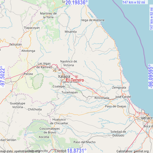
El Terrero GPS coordinates[2]
19° 32' 13.524" North, 96° 47' 56.652" West
| Map corner | latitude | longitude |
|---|---|---|
| Upper-left | 20.19836°, | -97.5022° |
| Center: | 19.53709°, | -96.79907° |
| Lower-right: | 18.8731°, | -96.09595° |
| Map W x H: | 147.4×147.4 km | = 91.6×91.6mi |
| max Lat: | 32.7° ⇑53.4% North |
| El Terrero: | 19.53709° |
| min Lat: | ⇓46.6% South 14.53588° |
| min Long | El Terrero | max Long |
| -117.105° | -96.79907° | -86.73105° |
| W 77.3%⇐ | ⇒22.7% E |
Elevation
Elevation of El Terrero is 1065 m = 3494 ft, and this is 188.7 m = 619 ft below average elevation for this country.
| Max E: |
3497 m = 11473 ft | 58.7% |
| Avg. | 1253.7 m = 4113 ft | |
| El Terrero | 1065 m = 3494 ft | |
Min E: |
-1 m = -3 ft | 41.3% |
See also: Mexico elevation on elevation.city.
Geographical zone
El Terrero is located in North Torrid zone (between Equator and Tropic of Cancer). Distance of this Northern Tropic circle is 433.6 km =269.4 mi to North.| Distance of | km | miles | from El Terrero |
|---|---|---|---|
| North Pole | 7834.7 | 4868.3 | to North |
| Arctic Circle | 5228.9 | 3249.1 | to North |
| Tropic Cancer | 433.6 | 269.4 | to North |
| Equator | 2172.3 | 1349.8 | to South |


Nearby cities:
15 places around El Terrero: (largest is in red/bold)
• Almolonga
6.1 km =3.8 mi,  15°
15°
• Chiltoyac
8.4 km =5.2 mi,  302°
302°
• Dos Ríos
5.9 km =3.7 mi,  180°
180°
• El Castillo
6.9 km =4.3 mi,  278°
278°
• El Lencero
5.6 km =3.5 mi,  198°
198°
• Jacarandas
7.3 km =4.5 mi,  230°
230°
• La Tinaja
5.1 km =3.2 mi,  117°
117°
• Las Trancas
7.8 km =4.8 mi,  242°
242°
• Lomas de Miradores
8.7 km =5.4 mi,  171°
171°
• San Antonio Paso del Toro
6.6 km =4.1 mi,  321°
321°
• San Nicolás
3.8 km =2.4 mi,  56°
56°
• Seis de Enero
4.9 km =3 mi,  313°
313°
• Trapiche del Rosario
6.1 km =3.8 mi,  83°
83°
• Tronconal
7.4 km =4.6 mi,  294°
294°
• Vicente Guerrero (Tepetates)
8.2 km =5.1 mi,  354°
354°
Sources, notices
• [Note1] Compared only with cities in Mexico existing in our database
• [Src1] Map data: © OpenStreetMap contributors (CC-BY-SA)
• [Src2] Other city data from geonames.org with taken over terms of usage.
• [Src3] Geographical zone / Annual Mean Temperature by Robert A. Rohde @ Wikipedia
