San Felipe Orizatlán geodata
San Felipe Orizatlán (Hidalgo) is a populated place; located in Mexico in America/Mexico_City (GMT-6) time zone. With population of 6,686 people, there are 1403 cities with bigger population in this country. Compared to other cities in Mexico, 78.8% of cities are located further ↓South; 56% of cities are located further ←West and 76.2% of cities have higher elevation than San Felipe Orizatlán. Note1
Current local time in San Felipe Orizatlán:
06:48 AM, WednesdayDifference from your time zone: hours


San Felipe Orizatlán GPS coordinates[2]
21° 10' 15.924" North, 98° 36' 26.784" West
| Map corner | latitude | longitude |
|---|---|---|
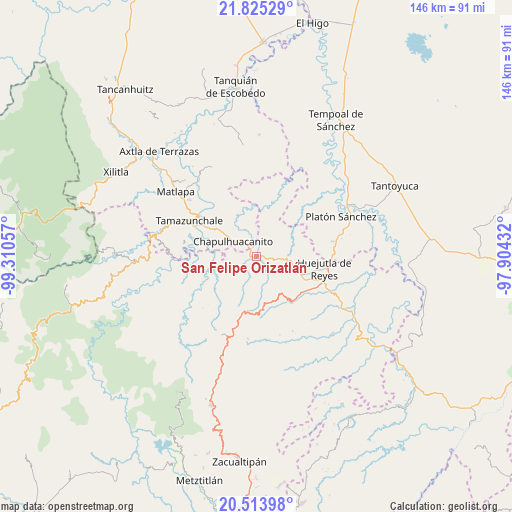
| Upper-left | 21.82529°, | -99.31057° |
| Center: | 21.17109°, | -98.60744° |
| Lower-right: | 20.51398°, | -97.90432° |
| Map W x H: | 145.8×145.8 km | = 90.6×90.6mi |
| max Lat: | 32.7° ⇑21.2% North |
| San Felipe Orizatlán: | 21.17109° |
| min Lat: | ⇓78.8% South 14.53588° |
| min Long | San Felipe Oriz | max Long |
| -117.105° | -98.60744° | -86.73105° |
| W 56%⇐ | ⇒44% E |
Elevation
Elevation of San Felipe Orizatlán is 178 m = 584 ft, and this is 1075.7 m = 3529 ft below average elevation for this country.
| Max E: |
3497 m = 11473 ft | 76.2% |
| Avg. | 1253.7 m = 4113 ft | |
| San Felipe Orizatlán | 178 m = 584 ft | |
Min E: |
-1 m = -3 ft | 23.8% |
See also: Mexico elevation on elevation.city.
Geographical zone
San Felipe Orizatlán is located in North Torrid zone (between Equator and Tropic of Cancer). Distance of this Northern Tropic circle is 251.9 km =156.5 mi to North.| Distance of | km | miles | from San Felipe Orizatlán |
|---|---|---|---|
| North Pole | 7653.1 | 4755.4 | to North |
| Arctic Circle | 5047.2 | 3136.2 | to North |
| Tropic Cancer | 251.9 | 156.5 | to North |
| Equator | 2354 | 1462.7 | to South |


Nearby cities:
15 places around San Felipe Orizatlán: (largest is in red/bold)
• Ahuatitla
6.1 km =3.8 mi,  263°
263°
• Chapulhuacanito
7.8 km =4.8 mi,  303°
303°
• Coacuilco
7.8 km =4.8 mi,  163°
163°
• Cochiscuatitla
7 km =4.3 mi,  56°
56°
• Cuapaxtitla
7.1 km =4.4 mi,  126°
126°
• Cuatlimax
10 km =6.2 mi,  214°
214°
• Huitzitzilingo
5.1 km =3.2 mi,  272°
272°
• Jaltocan
8.3 km =5.2 mi,  120°
120°
• La Capilla
8.9 km =5.5 mi,  103°
103°
• Las Chacas
9.6 km =6 mi, 62°
• Potejamel
9.7 km =6 mi,  7°
7°
• Pueblo Hidalgo
9.7 km =6 mi,  229°
229°
• Talol
6 km =3.7 mi,  199°
199°
• Temango
9.7 km =6 mi,  242°
242°
• Totonicapa
1.9 km =1.2 mi,  140°
140°
Sources, notices
• [Note1] Compared only with cities in Mexico existing in our database
• [Src1] Map data: © OpenStreetMap contributors (CC-BY-SA)
• [Src2] Other city data from geonames.org with taken over terms of usage.
• [Src3] Geographical zone / Annual Mean Temperature by Robert A. Rohde @ Wikipedia
