Cuatlimax geodata
Cuatlimax (Hidalgo) is a populated place; located in Mexico in America/Mexico_City (GMT-6) time zone. With population of 657 people, there are 13209 cities with bigger population in this country. Compared to other cities in Mexico, 77.8% of cities are located further ↓South; 55.5% of cities are located further ←West and 66.3% of cities have higher elevation than Cuatlimax. Note1


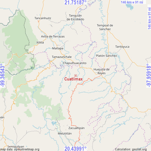
Cuatlimax GPS coordinates[2]
21° 5' 50.424" North, 98° 39' 44.28" West
| Map corner | latitude | longitude |
|---|---|---|
| Upper-left | 21.75187°, | -99.36543° |
| Center: | 21.09734°, | -98.6623° |
| Lower-right: | 20.43991°, | -97.95918° |
| Map W x H: | 145.9×145.9 km | = 90.7×90.7mi |
| max Lat: | 32.7° ⇑22.2% North |
| Cuatlimax: | 21.09734° |
| min Lat: | ⇓77.8% South 14.53588° |
| min Long | Cuatlimax | max Long |
| -117.105° | -98.6623° | -86.73105° |
| W 55.5%⇐ | ⇒44.5% E |
Elevation
Elevation of Cuatlimax is 625 m = 2051 ft, and this is 628.7 m = 2063 ft below average elevation for this country.
| Max E: |
3497 m = 11473 ft | 66.3% |
| Avg. | 1253.7 m = 4113 ft | |
| Cuatlimax | 625 m = 2051 ft | |
Min E: |
-1 m = -3 ft | 33.7% |
See also: Mexico elevation on elevation.city.
Geographical zone
Cuatlimax is located in North Torrid zone (between Equator and Tropic of Cancer). Distance of this Northern Tropic circle is 260.1 km =161.6 mi to North.| Distance of | km | miles | from Cuatlimax |
|---|---|---|---|
| North Pole | 7661.3 | 4760.5 | to North |
| Arctic Circle | 5055.4 | 3141.3 | to North |
| Tropic Cancer | 260.1 | 161.6 | to North |
| Equator | 2345.8 | 1457.6 | to South |


Nearby cities:
15 places around Cuatlimax: (largest is in red/bold)
• Ahuatitla
7.5 km =4.7 mi,  357°
357°
• Coacuilco
7.9 km =4.9 mi,  84°
84°
• Hueyapa
3.1 km =1.9 mi,  243°
243°
• Huitepec
7.9 km =4.9 mi,  232°
232°
• Huitzitzilingo
8.4 km =5.2 mi,  3°
3°
• Jalpa
5.4 km =3.4 mi,  283°
283°
• Pahuayo
9.6 km =6 mi,  332°
332°
• Pueblo Hidalgo
2.5 km =1.6 mi,  319°
319°
• San Felipe Orizatlán
10 km =6.2 mi,  34°
34°
• San José
7.7 km =4.8 mi,  113°
113°
• Santa Lucía
8.6 km =5.3 mi, 327°
• Talol
4.5 km =2.8 mi,  55°
55°
• Temango
4.8 km =3 mi, 322°
• Totonicapa
9.6 km =6 mi,  45°
45°
• Xuchitlán
9.3 km =5.8 mi,  246°
246°
Sources, notices
• [Note1] Compared only with cities in Mexico existing in our database
• [Src1] Map data: © OpenStreetMap contributors (CC-BY-SA)
• [Src2] Other city data from geonames.org with taken over terms of usage.
• [Src3] Geographical zone / Annual Mean Temperature by Robert A. Rohde @ Wikipedia
