Pueblo Hidalgo geodata
Pueblo Hidalgo (Hidalgo) is a populated place; located in Mexico in America/Mexico_City (GMT-6) time zone. With population of 1,183 people, there are 7346 cities with bigger population in this country. Compared to other cities in Mexico, 78.1% of cities are located further ↓South; 55.3% of cities are located further ←West and 66.7% of cities have higher elevation than Pueblo Hidalgo. Note1


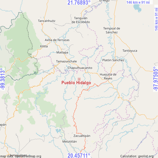
Pueblo Hidalgo GPS coordinates[2]
21° 6' 52.092" North, 98° 40' 41.412" West
| Map corner | latitude | longitude |
|---|---|---|
| Upper-left | 21.76893°, | -99.3813° |
| Center: | 21.11447°, | -98.67817° |
| Lower-right: | 20.45711°, | -97.97505° |
| Map W x H: | 145.9×145.9 km | = 90.7×90.7mi |
| max Lat: | 32.7° ⇑21.9% North |
| Pueblo Hidalgo: | 21.11447° |
| min Lat: | ⇓78.1% South 14.53588° |
| min Long | Pueblo Hidalgo | max Long |
| -117.105° | -98.67817° | -86.73105° |
| W 55.3%⇐ | ⇒44.7% E |
Elevation
Elevation of Pueblo Hidalgo is 603 m = 1978 ft, and this is 650.7 m = 2135 ft below average elevation for this country.
| Max E: |
3497 m = 11473 ft | 66.7% |
| Avg. | 1253.7 m = 4113 ft | |
| Pueblo Hidalgo | 603 m = 1978 ft | |
Min E: |
-1 m = -3 ft | 33.3% |
See also: Mexico elevation on elevation.city.
Geographical zone
Pueblo Hidalgo is located in North Torrid zone (between Equator and Tropic of Cancer). Distance of this Northern Tropic circle is 258.2 km =160.4 mi to North.| Distance of | km | miles | from Pueblo Hidalgo |
|---|---|---|---|
| North Pole | 7659.4 | 4759.3 | to North |
| Arctic Circle | 5053.5 | 3140.1 | to North |
| Tropic Cancer | 258.2 | 160.4 | to North |
| Equator | 2347.7 | 1458.8 | to South |


Nearby cities:
15 places around Pueblo Hidalgo: (largest is in red/bold)
• Ahuatitla
5.8 km =3.6 mi,  12°
12°
• Chantasco
9.6 km =6 mi,  309°
309°
• Coacuilco
9.6 km =6 mi,  97°
97°
• Cuatlimax
2.5 km =1.6 mi,  139°
139°
• Hueyapa
3.4 km =2.1 mi,  198°
198°
• Huitepec
8.1 km =5 mi,  214°
214°
• Huitzitzilingo
6.9 km =4.3 mi,  18°
18°
• Jalpa
3.7 km =2.3 mi,  260°
260°
• Pahuayo
7.2 km =4.5 mi,  336°
336°
• San Felipe Orizatlán
9.7 km =6 mi,  49°
49°
• Santa Lucía
6.1 km =3.8 mi,  331°
331°
• Talol
5.4 km =3.4 mi,  83°
83°
• Temango
2.3 km =1.4 mi, 325°
• Tianguispicula
8.9 km =5.5 mi, 341°
• Xuchitlán
8.9 km =5.5 mi,  230°
230°
Sources, notices
• [Note1] Compared only with cities in Mexico existing in our database
• [Src1] Map data: © OpenStreetMap contributors (CC-BY-SA)
• [Src2] Other city data from geonames.org with taken over terms of usage.
• [Src3] Geographical zone / Annual Mean Temperature by Robert A. Rohde @ Wikipedia
